
Introduction
Incident investigations often begin after the physical scene has already started to change. Equipment is moved. Cleanup starts. Temporary controls appear or disappear. Later reviewers are then asked to understand layout, access, and surrounding conditions from photographs, notes, and recollection.
Forensic mapping is a documentation method for that problem. Aerial and ground-based reality capture can preserve spatial context while it still exists. SterFlies captures and organizes those conditions. Qualified professionals interpret them.
This article explains what forensic mapping means in practice, what aerial and ground-based capture can each preserve, which deliverables are commonly produced, and where the method stops. It does not determine cause, fault, liability, code compliance, or whether a record will be accepted in a proceeding.
Photogrammetry, used throughout, is the reconstruction of visible geometry from overlapping photographs. Reality capture is the broader field practice of collecting those photographs, scans, or walkthroughs so the site can be reviewed after access is gone. Both are documentation methods. Neither is an investigation finding.
What forensic mapping actually means
In practical terms, forensic mapping is coordinated spatial documentation of a site at a dated moment. The useful result is a reviewable record of layout, scale, and relationships: where features sat, how they related, and what surrounded them.
It is not a legal certification, a survey stamp, or an investigation method. The word “forensic” here describes the documentation objective—preserving conditions for later review—not a finding about cause or responsibility. That distinction is developed in what forensic site documentation is.
Why incident scenes are difficult to reconstruct later
Incident scenes are working environments. After an event, the same actions that restore safety also change the record later reviewers will need. Equipment is relocated. Cleanup removes debris and staining. Weather alters surfaces. Repairs begin. Temporary barriers and access routes change. Site access may be restricted.
Recollections can also change as time passes and discussions continue. That is a reason to preserve the site itself, not a finding about any particular witness.
That timing problem is the subject of why site conditions should be documented before they are altered.
What aerial capture can preserve

Aerial photogrammetry can document a site from above when the capture is planned for coverage and overlap. Depending on scope, that can preserve overall site geometry; top-down context that ground photographs rarely show; access routes and staging areas; surrounding conditions beyond the immediate scene; excavation or trench geometry; relationships between equipment and structures; and hard-to-reach exterior areas such as roofs or large yards.
The output is a dated spatial record, not a conclusion about how an event occurred. How useful later measurements are depends on the capture plan, as described below. What aerial mapping specifically contributes, and where ground-based documentation is still required, is covered in how drone mapping can support forensic site investigations.
What ground-based reality capture can preserve

Ground-based reality capture documents interiors and close-range conditions that aerial methods cannot see. Depending on method, that can include room relationships, floor-level context, equipment spaces, corridors, work areas, and close-range surfaces.
Matterport and similar walkthrough systems are one interior capture method. They are useful when the objective is a navigable interior record. They are not the product, and they do not replace other methods when exterior geometry or measurement is the objective.
Why combining aerial and ground-based capture matters
Each method leaves gaps the other can fill. Aerial capture can show how a building sits on a yard, where access roads enter, and how an excavation relates to nearby structures. It cannot show a corridor, a mechanical room, or the floor around a machine. Interior capture can preserve those spaces and still leave the reviewer without site-wide orientation.
A trench or excavation incident is a common example. Aerial coverage can preserve the open geometry and surrounding grade. Ground-based capture can preserve shoring, adjacent work areas, and interior spaces that later reviewers may need to place relative to the excavation. The combination is documentation, not an accident reconstruction.

Common deliverables
Deliverables depend on the documentation objective and site constraints. A project may include some of the following, not all of them:
- Orthomosaic maps for scaled top-down context
- 3D models for navigable geometry
- Point clouds for later spatial review
- High-resolution stills for surface detail
- Interior walkthroughs for room-to-room orientation
- Annotated imagery for location context
- Measurements, when the capture is scoped for that use
- Supporting files such as dates, processing notes, and organized originals
Service options are described under forensic mapping and site documentation.
Measurement and accuracy
A spatial record can support later measurement when the capture geometry, sensor, processing, control, and site conditions allow it. Those factors vary by project. This work does not promise survey-grade accuracy, and it is not a substitute for a licensed survey when a legal survey is required.
Ground sample distance describes how much ground one image pixel represents. It is a resolution choice driven by flying height and sensor. It is not, by itself, a statement of how closely a later measurement will match a taped distance. Control points, surface visibility, and processing also matter. When a project needs a licensed survey, that work remains with a licensed surveyor.
While the aerial record can support exterior measurement context, some incident questions are not visible from above. Thermal imagery is one supporting layer that may be added when apparent temperature patterns are part of what a qualified reviewer needs to see.
Thermal documentation where relevant
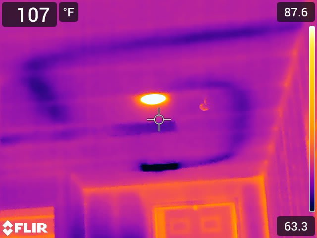
In some industrial or property-loss workflows, thermal imagery can be a supporting layer alongside RGB photographs and a spatial location. It records apparent temperature differences. It does not diagnose electrical faults, moisture, or equipment failure.
What forensic mapping does not do
Forensic mapping does not independently determine:
- causation
- liability
- negligence
- code compliance
- legal admissibility
- expert conclusions
Those questions belong to qualified professionals reviewing the record. Spatial documentation may later become part of a professional or legal workflow; it is not automatically evidence. See digital site documentation in legal disputes and chain of custody for digital site documentation.
A practical workflow
- Define the documentation objective.
- Review site and access constraints.
- Select capture methods that match that objective.
- Capture the site while original context still exists when possible.
- Process the spatial outputs required by the scope.
- Organize records so later reviewers can see what was captured and when.
- Deliver the record for qualified review.
When documentation should happen
The useful moment is while site context still exists—before cleanup, repairs, or restricted access remove what later reviewers will need. Early capture is not a prediction that a claim or investigation will follow. It is a way to keep layout and surroundings available if they are needed later.
Waiting until an investigation is formally opened often means documenting a site that has already been made safe. That later record can still be useful. It should be described as a record of the altered site, not as a substitute for the conditions that cleanup removed.
Related professional workflows
The same documentation approach can support later review in incident investigation, construction safety, industrial hygiene, property loss, construction-defect questions, and expert review. SterFlies does not perform those conclusions. Expert witnesses still need more than photographs. Interior existing-conditions work is shown in the IAQ and mold documentation project.
Conclusion
Forensic mapping preserves the spatial context of an incident scene while that context still exists. Aerial photogrammetry can hold site layout, access, and surrounding grade. Ground-based capture can hold interiors, close surfaces, and work areas an overhead camera cannot see.
Orthomosaics, models, point clouds, stills, and walkthroughs are deliverables of that record. Measurements from them depend on the capture plan. They are not a licensed survey, and thermal patterns included in the same package are not a diagnosis.
The method does not determine cause, fault, liability, or whether a file will be accepted later. It gives qualified professionals a dated view of layout and relationships they can review after the physical scene has changed.