
Introduction
An investigation often begins after the physical environment has already started changing. Ground photographs remain useful. They document particular viewpoints, surfaces, and details. A later reviewer still has to assemble those frames into a picture of the site.
Aerial mapping can preserve a broader spatial view. Overlapping aerial imagery can be processed into a mapped record of layout and relationships, so qualified professionals can later examine how major site elements relate to one another. The record documents visible conditions. Cause remains a separate professional question.
This article is about that aerial contribution. The broader method, which pairs aerial and ground-based reality capture, is forensic mapping for incident investigations.
The purpose is to explain what drone mapping can add to a forensic site investigation, which spatial products can be produced from a mapping mission, and where an overhead record has to be supplemented by ground-based capture and professional interpretation. It does not establish cause, fault, liability, or whether a file will be accepted later.
What drone mapping adds to a site investigation
An aerial photograph and a mapped aerial dataset answer different questions.
A single photograph records one camera position. It can be sharp and still leave a later reviewer unsure which way the camera faced, how far the subject sat from a structure, or how that view connects to the rest of the property.
A mapping mission uses many overlapping images. Photogrammetric processing aligns those images and reconstructs a broader representation of visible site geometry and spatial relationships. The result can be reviewed as a layout, alongside the original frames. How an orthomosaic is produced is covered in understanding orthomosaic mapping. The question here is where that kind of record helps an investigation.
Attorneys, safety professionals, consultants, and investigators often review a site they did not see at the time of capture. A mapped view gives them a shared frame of reference before they examine individual images. That practice sits inside what forensic site documentation is: preserving conditions for later review.
Preserving the overall site layout
Orientation is the first thing a later reviewer has to recover. A large set of ground photographs can show equipment, surfaces, and work areas clearly while the site itself stays difficult to assemble. Each frame has its own direction and crop. A temporary feature may appear in one photograph and be absent from the next.
An overhead mapped record can hold those features in one spatial view:
- buildings and other structures
- roadways and access routes
- work zones
- equipment locations
- surrounding property
- excavations
- terrain
- temporary site features such as barricades, laydown areas, and trailers
Close photographs still carry the detail. The mapped view gives them a place. Experts asked to review a site after conditions have changed often need that orientation before a detail photograph becomes meaningful. That limitation of isolated photographs is discussed in why expert witnesses need more than photographs to analyze a site.
Documenting conditions before the site changes
Sites under investigation are working places. Exterior conditions can change for ordinary operational reasons:
- equipment is moved
- debris is removed
- an excavation is backfilled
- barricades are taken down
- repairs start
- temporary structures are removed
- weather changes surface conditions
A mapped aerial record is a dated view of the exterior as it existed at capture. Documentation made after those changes records what remains. The timing question is developed in why site conditions should be documented before they are altered.
Capturing the exterior while it is still available is a way to keep layout on record if someone needs to review it later.
Construction and industrial incident environments
Investigations involving construction sites, excavations, cranes, industrial facilities, or other large physical environments can require documentation of relationships that are difficult to understand from isolated ground photographs alone. The examples below are documentation uses.
Excavations and trenches
An open excavation is a spatial object. Length, visible depth, slope, nearby surfaces, and the position of equipment are difficult to hold together in photographs taken from the edge.

Aerial capture may provide:
- overall excavation geometry, as visible from above
- surrounding surface conditions
- nearby equipment
- access points
- spoil or other material locations
- the relationship between the excavation and the surrounding site
Excavation safety practice treats access, spoil placement, and equipment near the opening as conditions that affect the work area. An overhead record can preserve the visible arrangement of those features. Soil classification, protective-system evaluation, and the reason for a collapse remain with a qualified investigator.
Crane and rigging incidents
After a crane or rigging incident, later reviewers often need to understand where the crane sat, what occupied the work zone, and which structures, access limits, or other equipment surrounded the lift. Photographs of the crane can miss that wider arrangement.
Aerial capture may help preserve:
- crane location
- work-zone layout
- nearby structures
- access constraints
- surrounding equipment
- overhead and site context that was visibly documented
Load dynamics, sling capacity, and the reason a lift failed are expert questions. A mapped site record does not answer them.
Construction sites
An active construction site is a changing arrangement of work areas, materials, temporary conditions, and access. A mapped aerial record may document:
- work areas
- relationships between buildings and the site
- the visible progress state at the time of capture
- temporary conditions
- material locations
- surrounding access
The record shows what was visible at capture. Specification compliance and responsibility for a condition remain professional questions.
Industrial facilities
Exterior aerial capture can provide broader site context around equipment areas, structures, process areas, access, and exterior conditions. On many industrial sites that overhead view is an orientation layer. The conditions that matter for a particular question may sit inside a building, under a structure, or inside equipment.
Professional review of these environments can involve construction safety, industrial hygiene, crane and rigging analysis, process safety, and incident investigation. Those disciplines appear in Spear & Lancaster’s public descriptions of its professional work. SterFlies does not perform them. Aerial mapping supplies a spatial record that qualified professionals can review.
What can be created from a drone mapping mission
Outputs depend on the documentation objective, the capture, and processing. A project may include some of the following.
Orthomosaic

An orthomosaic is a stitched, top-down spatial image of the site. Camera perspective is reduced so the site can be read more like a map than like a single oblique photograph. Reviewers use it for orientation, context, reference, and annotation: a work zone, an access route, or the position of equipment relative to a structure.
3D model

A 3D model is a reconstructed representation of visible site geometry. It can be navigated to see how surfaces and structures sit relative to one another. Typical uses are navigation, orientation, and visual review. The model represents surfaces the imagery could reconstruct.
Point cloud

A point cloud is a dense spatial representation derived from the capture and processing. It can support geometry review, visualization, and downstream technical workflows when those workflows are in scope. It represents visible surfaces that were imaged.
Unlike a photograph, a point cloud can be rotated and sectioned so a later reviewer can look at the same surfaces from more than one direction. Unlike a licensed survey, it is only as useful as the imagery, overlap, and control that produced it. Vegetation, standing water, and surfaces the camera never saw remain gaps.
High-resolution aerial imagery
Individual oblique and contextual photographs still matter alongside the mapped products. A frame can show a facade, a label, or a surface condition more directly than a top-down map. The mapped record and the stills work as a set: one for layout, the others for a particular viewpoint.
An orthomosaic answers where a feature sits in the site. An oblique frame answers what that feature looked like from the side. Keeping both prevents the top-down map from being asked to carry detail it was not built to show, and prevents a single dramatic still from being asked to carry the layout.
Measurements
Measurements may be available from a processed aerial dataset. Whether they are appropriate depends on capture geometry, processing, project control, site conditions, and the accuracy the project needs. A licensed survey remains a separate professional service when one is required.
Ground sample distance—the ground area represented by one image pixel—is a planning choice, not a guarantee that every later measurement will match a field tape. Reported distances should stay tied to the capture that produced them. When a question requires a stamped survey, that work is outside this documentation.
Why aerial mapping should not stand alone
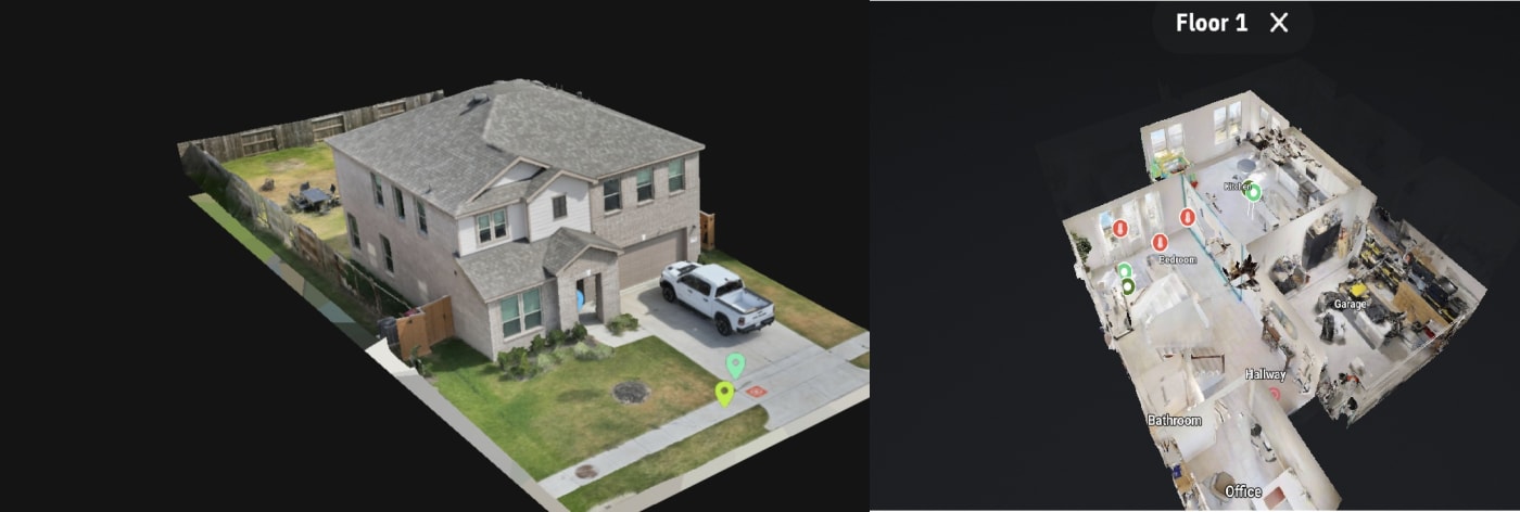
An overhead record documents surfaces the camera could see. It may not adequately capture:
- interiors
- obscured surfaces
- areas beneath structures
- enclosed equipment spaces
- details blocked by vegetation
- conditions that require close inspection
- information that requires physical testing
Aerial mapping is therefore often combined with terrestrial photography, Matterport or similar walkthrough capture, 360 capture, close-range imagery, thermal imaging, measurements, and professional inspection or testing. The method follows the question. Interior existing-conditions work is a ground-based record, as in the IAQ and mold documentation project.
Choosing and organizing those methods is forensic mapping and site documentation. Aerial mapping is one method inside that practice.
Drone mapping does not determine causation
Aerial mapping documents conditions. It does not independently establish:
- cause
- fault
- negligence
- code compliance
- liability
- legal admissibility
- expert conclusions
A spatial file may later be used in a professional or legal workflow. Organizing files, dates, and originals is a documentation practice, discussed in chain of custody for digital site documentation. Organization of the record is separate from any legal conclusion.
How aerial mapping fits into an investigation workflow
The steps below are a documentation workflow for aerial capture. They are a way to plan and deliver a site record.
- Define the documentation objective. Decide which relationships still need to be understandable after the site changes.
- Review access and site constraints, including airspace, obstructions, and areas that cannot be flown.
- Plan aerial coverage so the overlap and extent match that objective.
- Capture overlapping imagery while the relevant exterior conditions are still present.
- Process the mapping dataset into the outputs the scope requires.
- Organize spatial deliverables with the stills, dates, and supporting files a later reviewer will need.
- Provide the record for professional review.
Qualified professionals interpret the record. SterFlies captures and organizes it.
When drone mapping is especially useful
Aerial mapping fits when an investigation needs exterior context that ground photographs do not assemble well. That often includes:
- large sites
- construction incidents
- excavations
- industrial facilities
- exterior property loss
- sites with complicated spatial relationships
- areas where broad overhead context matters
- sites expected to change soon
A question that lives in a room, a shaft, or enclosed equipment may need little aerial coverage. The useful method is the one that preserves the conditions the investigation actually has to review.
Aerial and ground-based documentation work better together
Aerial mapping provides broad site context. Ground-based capture provides close and interior context. Together they give a later reviewer both the layout and the spaces an overhead camera cannot enter.
The documentation method should be selected around the investigation’s actual needs. That combined approach is the subject of forensic mapping for incident investigations. To scope an exterior record before conditions change, discuss a project.
Conclusion
Drone mapping can preserve the broader exterior of a site while that exterior still exists. Overlapping aerial imagery can be processed into an orthomosaic, a navigable model, a point cloud, and a set of still photographs that keep layout and viewpoint together.
Those products document visible conditions. They do not determine cause, fault, or liability, and they do not replace a licensed survey when one is required. Interiors, obscured surfaces, and questions that need close inspection or testing still need ground-based capture and qualified review.
The practical takeaway is timing and method. Capture the exterior relationships before cleanup and repair remove them, pair the overhead record with the spaces it cannot see, and leave interpretation to the professionals who are qualified to make it.