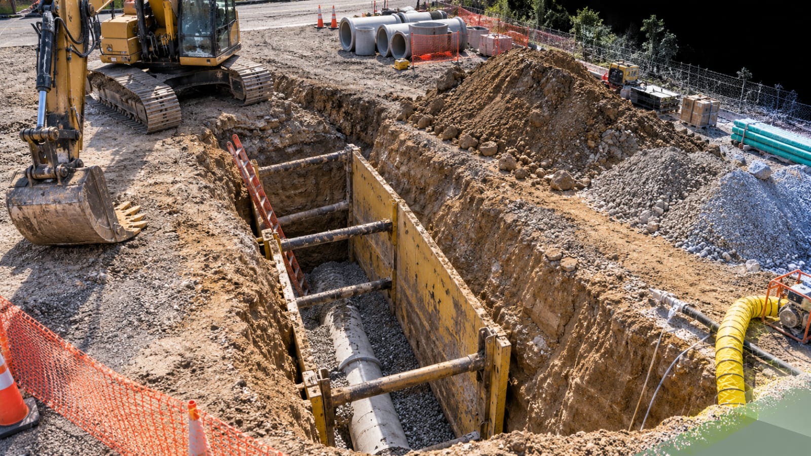
Excavation and trenching incidents present a documentation problem that is unusually sensitive to time. The physical scene that exists immediately after an incident may not remain available for long. Soil may be moved to stabilize an area or continue construction. A trench wall may be reshaped. Protective systems may be removed or repositioned. An excavator may be driven away. Standing water may accumulate or be pumped out. Spoil piles may be relocated. Access points may change. Repairs, cleanup, grading, or backfilling may eventually remove the excavation altogether.
These changes can be necessary for safety, recovery, or continued work, but they also create a practical challenge for later review. An attorney, engineer, safety professional, consultant, insurer, or expert witness may become involved after the original configuration is gone. At that point, the reviewer is no longer examining the original physical scene. The reviewer is examining whatever record was created while that scene still existed. Conditions are most useful when they are documented before they are altered.
For that reason, excavation documentation is most useful when it preserves more than isolated details. It should preserve the excavation as part of a larger physical environment. Geometry, access, protective systems, nearby equipment, spoil piles, utilities, structures, roadways, terrain, drainage, and other visible conditions can all contribute to understanding where objects were and how different parts of the site related to one another. That is the practical aim of forensic mapping for incident investigations.
This does not mean that documentation explains why an incident occurred. It does not establish fault, determine compliance, classify soil, evaluate the adequacy of an engineered system, or replace the work of a qualified investigator. The purpose of forensic site documentation is narrower. It preserves observable conditions and spatial relationships so that qualified professionals have a more complete record to interpret later.
A Scene That Can Become Different Within Hours
The distinction between an excavation and a trench is useful at the outset. OSHA defines an excavation broadly as a cut, cavity, trench, or depression created by earth removal. A trench is a narrower type of excavation that is generally deeper than it is wide, with a bottom width of no more than fifteen feet (Occupational Safety and Health Administration, “1926.650”).
Both are temporary environments. Their geometry exists because earth has been removed, and that geometry can be changed quickly by the same equipment that created it. A bucket can alter a wall or floor within minutes. Additional excavation can change depth, width, or wall configuration. Soil can slough or collapse. Water can collect. A trench box can be moved as work advances. Spoil can be loaded into trucks. Materials can be delivered or removed. Traffic patterns can change around the opening.
OSHA excavation requirements illustrate how many physical relationships can matter around such a work area. The standards separately address underground installations, access and egress, mobile equipment, water accumulation, adjacent structures, loose soil and rock, excavated material near the edge, and inspections of the excavation and surrounding area (Occupational Safety and Health Administration, “1926.651”). OSHA also treats sloping, benching, shoring, shielding, and other protective systems as distinct concepts within excavation safety practice (Occupational Safety and Health Administration, “1926.652”).
Those requirements should not be treated as a checklist for a documentation company to determine compliance. They are useful here for a different reason. They demonstrate that an excavation cannot always be understood by looking only at the hole in the ground. The surrounding arrangement can matter. A later professional may need to see the excavation together with its access, equipment, material placement, nearby structures, drainage, and visible protective systems.
NIOSH has likewise documented the severe consequences associated with trench cave ins and has emphasized the importance of protective systems and safe work practices in trenching operations. Its guidance concerns prevention rather than site documentation, but it reinforces why these environments receive specialized professional attention (National Institute for Occupational Safety and Health).
Once the excavation is backfilled, the original geometry cannot simply be photographed again. Once an excavator is moved, its former position must be reconstructed from whatever record exists. Once water is pumped away, the earlier visible extent of standing water is no longer directly observable. The value of early documentation therefore comes from preserving the configuration that was actually present at a known time.
Preserving the Excavation as a Physical Space
A useful excavation record begins with geometry, but geometry means more than a single depth measurement.
The documented record may need to show the length and width of the excavation, visible depth where it can be established appropriately, the configuration of the walls, changes in elevation, and the relationship between the excavation floor and the surrounding grade. If sloping or benching is visible, its form can be recorded. If a trench box, shield, shoring system, or another protective system is present, its visible position relative to the trench can be documented without making a judgment about its design or adequacy.
Access deserves similar attention. A ladder photographed closely may show its condition and construction, but a wider record can show where the ladder was located within the trench. A ramp can be documented together with the path leading toward it. Multiple access points can be related to the overall length and configuration of the excavation.
This distinction matters because a detailed photograph and a spatial record answer different questions. A close photograph may show the ladder clearly. A mapped or three dimensional record may show where that ladder was relative to a particular end of the trench, a trench box, a machine, or another feature. The two forms of documentation complement one another.
Nearby objects should receive the same treatment. Excavators, loaders, trucks, pumps, pipes, stored materials, spoil piles, barriers, utilities, and temporary structures can be documented in relation to the excavation rather than as disconnected subjects. A reviewer may later need to understand not simply that an excavator was present, but where it was positioned relative to the excavation edge and surrounding work area. The documentation preserves that relationship. It does not decide whether the position was appropriate.
The same principle applies to visible ground conditions. Surface disturbance, cracking, loose material, standing water, runoff paths, exposed strata, vegetation, and surrounding grade may be photographed when they are visible. Such imagery is a record of appearance. It is not a substitute for geotechnical testing, soil classification, engineering analysis, or other professional evaluation.

Why Photographs Alone May Leave Spatial Questions
Conventional photography remains essential to excavation documentation. Close photographs can preserve labels, surfaces, equipment details, visible wall conditions, components of a protective system, utilities, pipe connections, damage, and other subjects that may be too small to interpret in a site wide model.
The limitation is not that photographs lack detail. The limitation is that every photograph has a boundary.
A frame may clearly show a trench wall while excluding the excavator beside it. Another may show a spoil pile but not the point along the excavation where it was located. A photograph taken from inside or near an excavation may give little indication of which direction the camera faced unless that orientation is recorded separately. A later reviewer who was not present must then reconstruct the relationships between images.
That task becomes more difficult as the number of photographs grows. A set of two hundred technically good images can still require the reviewer to infer how one frame connects to another. Folder structure, filenames, notes, camera sequence, and captions help, but each places part of the spatial reconstruction outside the photograph itself.
A broader spatial record can provide the organizing layer. An orthomosaic mapping product, which is a map like image assembled from overlapping photographs, can show the excavation in plan together with roads, structures, equipment, materials, and surrounding terrain. Individual ground photographs can then be associated with known areas of that larger view.
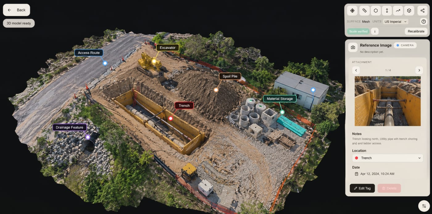
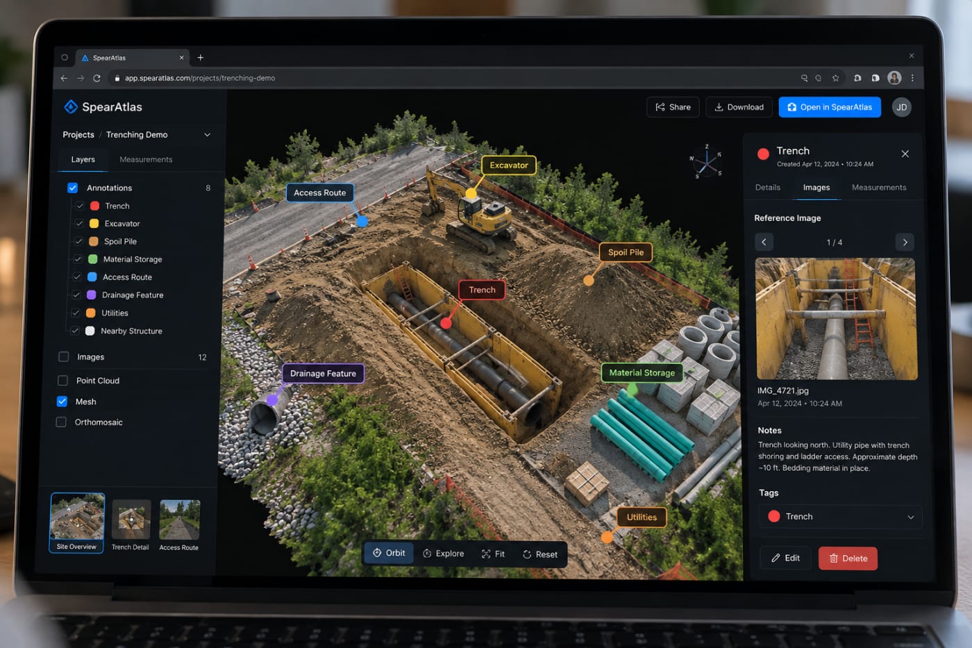
Annotations can strengthen that relationship further. A location on the map or model can identify where a photograph was taken, where a particular condition was observed, or which object a note refers to. The annotation does not transform the observation into an expert conclusion. It makes the record easier to navigate.
For someone who never visited the original scene, that difference can be significant. Instead of receiving a sequence of unrelated views, the reviewer can begin with the site as a whole, locate the excavation, understand the surrounding layout, and then move toward the detailed photographs.
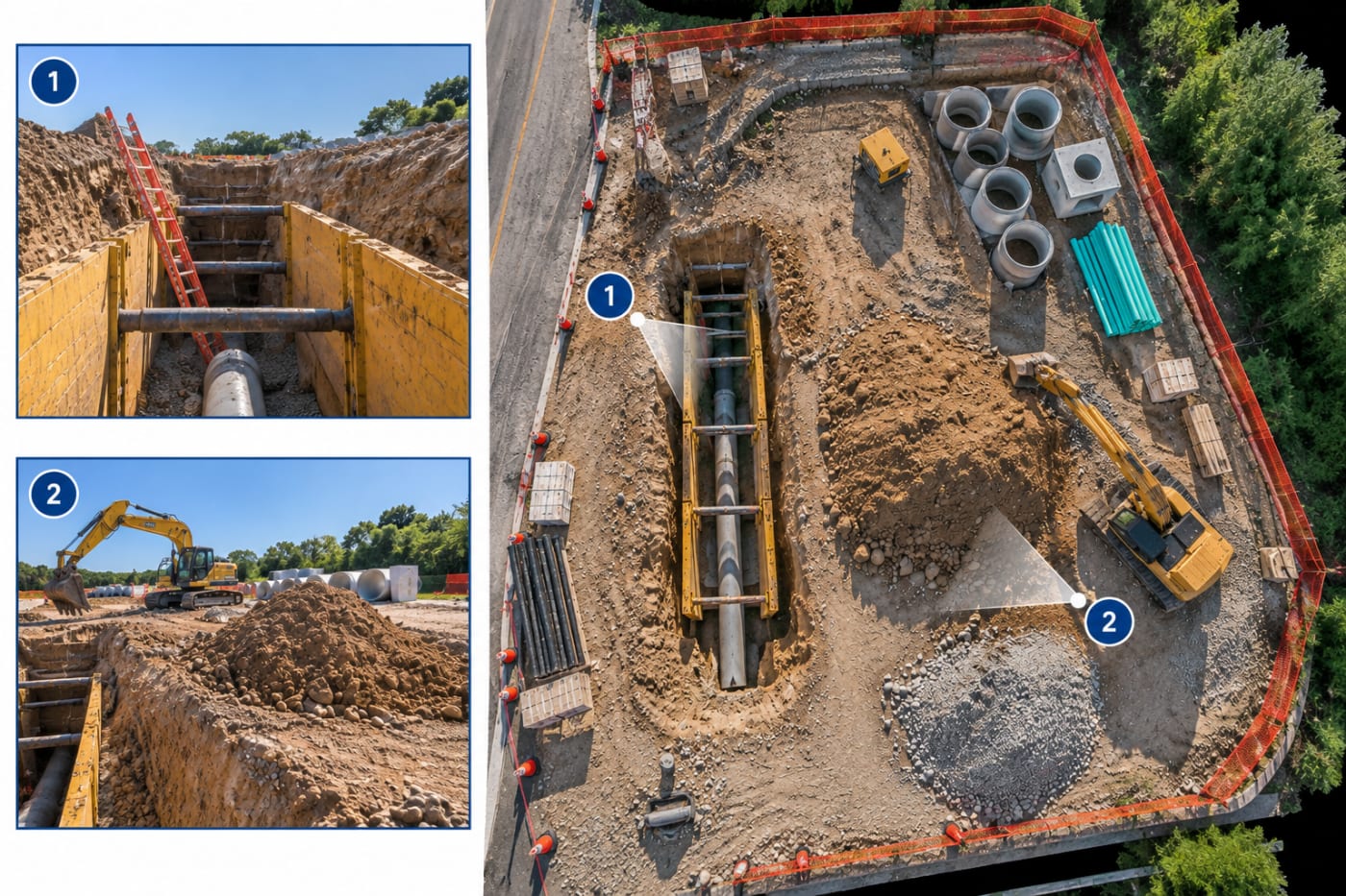
From Surface Imagery to a Reviewable Spatial Record
Different spatial products preserve different aspects of an excavation scene. They should be selected according to the documentation objective rather than treated as interchangeable outputs.
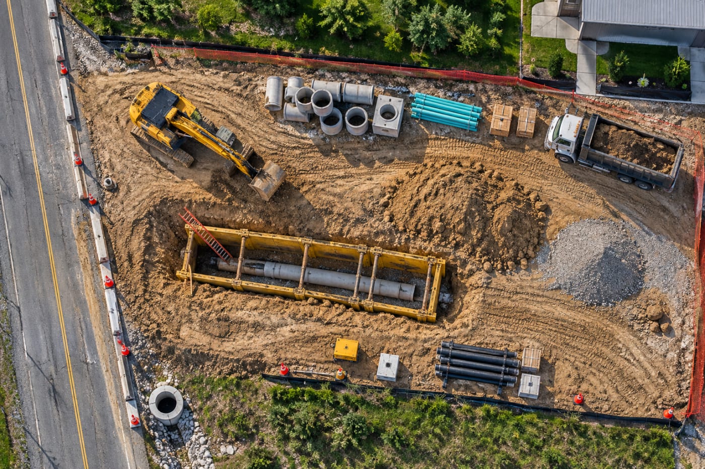
An orthomosaic is especially useful for plan view context. From above, a reviewer may be able to see the excavation alignment, nearby roadways, access paths, equipment, spoil areas, materials, adjacent structures, and broader site boundaries in one image. Where the underlying capture and processing support measurement, mapped imagery can also provide a reference for distances between visible features. Such measurements remain dependent on the quality and control of the original capture and should not be represented as a licensed survey when one was not performed.
Interactive 3D models add perspective that a plan view cannot. They can preserve visible wall geometry, changes in surrounding grade, equipment shape, material piles, and the relationship between objects at different elevations. The reviewer can rotate the scene and examine the documented surfaces from viewpoints that were not necessarily used for the original photographs.
These products can be particularly useful when trench geometry is difficult to understand from the edge. Width may vary along the excavation. One wall may have a different configuration from another. The surrounding grade may rise toward a roadway or structure. Protective equipment may occupy only part of the trench. A navigable model can preserve these relationships together, provided the relevant surfaces were visible to the cameras or other capture systems.
Measured site imagery can add another layer. A reviewer might need a documented distance between two visible objects, the approximate extent of a particular area, or a reference dimension across part of the excavation. Measurements should remain traceable to the dataset from which they were derived, and their reported precision should match the capabilities of the capture rather than implying certainty the documentation cannot support.
The purpose is not to produce the greatest possible number of digital products. The purpose is to preserve enough spatial information that the site remains understandable after its original configuration is gone.
Context Beyond the Edge of the Excavation
A narrow focus on the trench itself can create a detailed record that still lacks context.
Excavation incidents occur within larger work environments. There may be an adjacent building, retaining wall, roadway, utility corridor, material staging area, drainage path, fence, slope, or equipment route. The excavation may cross one part of a much larger construction site. Vehicles may approach from one direction. Spoil may occupy another. A pump may discharge water toward a particular area. Underground or exposed utilities may connect the excavation to structures elsewhere on the property.
Documenting these surroundings makes it possible to return from the detail to the site.
An aerial orthomosaic is often useful for this purpose because it can preserve the excavation and its surroundings in a common plan view. Aerial capture of that kind is discussed in drone mapping for forensic site investigations. Ground photographs remain necessary for details hidden from above. Close range imagery may be required for the inside faces of a trench, protective system components, pipe work, utilities, or objects beneath equipment.
Interior documentation can also matter when the excavation exists beside or connects to a building. A basement, mechanical room, utility entry, foundation area, or other interior space may relate physically to exterior work. In that situation, exterior photogrammetry and interior reality capture document different parts of the same environment. They do not necessarily have to become one continuous model to help a reviewer understand that relationship.
Context also includes features that may seem secondary during the original visit. The position of a parked machine, a temporary material pile, a fence opening, a drainage channel, or an access road may later help a reviewer orient another photograph. Broad documentation is valuable precisely because the person capturing the site may not know every question that will be asked months later.
That does not justify indiscriminate capture. Site access, privacy, safety, flight restrictions, project scope, and relevance still matter. The objective is a deliberate record of the environment surrounding the excavation, not an unlimited collection of imagery.
Remote Review After the Physical Scene Is Gone
The practical value of structured documentation becomes clearer once the site changes.
A trench that has been backfilled cannot be revisited in its former configuration. Equipment that has left the property may not return to the same position. Repairs can cover exposed work. Continued construction can replace temporary access routes and material locations. Weather can alter soil appearance and standing water.
Remote site review after conditions change depends on a spatial record that lets a later reviewer examine what was documented without requiring the physical site to remain unchanged. An orthomosaic can restore site orientation. A model can provide views of captured geometry. Ground photographs can supply close detail. Annotations can connect observations to locations.
A web based project viewer can make these records accessible to professionals who were not present during capture. A consultant may begin with the overall site, move toward the excavation, examine a measurement or annotation, and then open a related photograph. The technology used to deliver that experience is secondary to the underlying record.
What the Record Cannot Establish
Reality capture preserves visible information. That boundary is fundamental.
A camera does not classify soil. A three dimensional model does not determine whether a protective system was properly designed. An orthomosaic does not establish whether an employer complied with a regulation. A visual record does not reveal a condition hidden beneath soil or behind an opaque surface. It does not determine why a wall failed, why equipment was positioned in a particular location, or what decisions were made before the documentation began.
Some surfaces may also be difficult or impossible to reconstruct. Standing water can obscure the excavation floor and may process poorly in photogrammetric datasets. Deep or narrow excavations can contain surfaces that aerial cameras cannot see. Machinery, shoring, pipes, vegetation, shadows, and other objects can block portions of the scene. A wall visible from one direction may be hidden from another. Access restrictions may prevent ground photography from filling those gaps.
Timing creates another limitation. Documentation represents the site at the time it was captured. If material had already been moved before the documentation team arrived, the resulting record cannot establish its earlier position without other evidence. If a trench wall had already changed, the model preserves the changed wall. A digital record should never be described as though it captured a condition that no longer existed.
Measurement carries similar limits. Distances derived from photogrammetry or other reality capture methods depend on capture geometry, scale, control, surface visibility, processing, and the intended accuracy of the project. A documentation dataset should not be presented as a licensed survey unless the work actually satisfies the requirements for one and is performed under the appropriate professional authority.
Legal use is also a separate question. Creating an organized digital record does not automatically make that record admissible evidence. Questions involving evidentiary foundation, authentication, legal responsibility, regulatory interpretation, engineering conclusions, or expert opinions belong to the professionals responsible for those matters.
SterFlies documents observable conditions. Qualified professionals interpret the record.
Preserving Context Before It Disappears
The defining challenge of an excavation or trenching scene is not simply that it contains many details. It is that the relationships among those details may be temporary.
The excavation has a particular width and wall configuration. A ladder occupies a particular location. A trench box sits within a particular section. An excavator stands at a particular position. Spoil, utilities, roads, structures, drainage, materials, and surrounding terrain form a larger arrangement around the opening. Continued work can change every one of those relationships.
A useful documentation record preserves the ability to move between scales. It should allow a later reviewer to see the site as a whole, locate the excavation within it, understand the visible geometry of the excavation, identify surrounding objects, and then move toward the photographs or annotations that preserve individual details.
Orthomosaics, three dimensional models, mapped imagery, measurements, photographs, and annotations are different ways of carrying portions of that context forward. None of them determines causation. None replaces engineering analysis, safety investigation, legal review, testing, or professional judgment.
Their value is more fundamental. They allow physical conditions that may exist only briefly to remain available for later examination as an organized record.
When excavation scenes are documented before backfilling, repair, cleanup, continued construction, or equipment relocation changes them, qualified professionals can review not only what individual objects looked like, but where those objects existed in relation to the excavation and the rest of the site. That preserved spatial context is what makes technical field documentation useful after the original scene is no longer there.