Introduction
A site is rarely one surface. The roof, the yard, and the approach are visible from the air. The rooms, the corridors, and the equipment that sit inside are not. Professional documentation fails when one of those records is asked to stand in for the other. An orthomosaic cannot show a mechanical room. An interior walkthrough cannot show how the building sat on the lot.
Combining exterior photogrammetry with interior reality capture is a way to keep both. The two datasets answer different questions, and they are useful together because a later reviewer usually has both questions. This article explains what each method preserves, how they complement each other, and what they still do not do. The documentation practice is forensic mapping and site documentation. What that practice is for, and what it refuses to conclude, is set out in what forensic site documentation is.
The exterior and interior gap
Photographs of a facade and a separate folder of room pictures can both be careful and still leave the relationship between them to memory. Which room sat behind which window, which corridor reached the equipment, and how the entry related to the yard are the facts that slip. Months later, a reviewer is left matching filenames to a floor plan that may itself be out of date.
The gap is spatial, not a shortage of megapixels. Exterior capture and interior capture have to be planned as parts of one documentation objective, or they remain two unrelated sets of pictures. Planning them together does not fuse them into a single surveyed model. It does put the exterior context and the interior continuity into the same delivery, with the limits of each method stated.
What aerial photogrammetry captures well
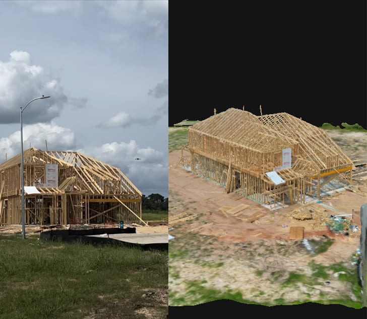
Overlapping aerial photographs reconstruct the surfaces the aircraft could see: roofs, open yards, paving, stockpiles, excavation, and the outside of buildings. From that reconstruction a project can receive an exterior 3D model, an orthomosaic, and, when the scope asks for it, a point cloud. Those products are the right record for site relationships. How a building sat relative to access, where a work area was in the yard, and what the visible envelope looked like at the time of capture.
The same method supports measurement on those visible surfaces when the capture and any control were planned for measurement. A point cloud from that flight is a sample of those surfaces, not a complete solid of the building. The orthomosaic is the plan-view map. The mesh is the viewable exterior model. Each one stops at the line of sight.
What aerial capture cannot see
The aircraft does not see rooms. It does not see the underside of a deck, the face of a wall hidden by a trailer, or the equipment behind a roof screen. Vegetation, overhangs, and adjacent structures remove surfaces the same way. Flight limits and occupied areas remove others. Those are not defects in the orthomosaic. They are the boundary of an overhead method, and USGS descriptions of structure-from-motion processing state the same boundary in technical terms: a surface that was not adequately photographed is not reconstructed.
Trying to answer an interior question with an exterior model produces a confident gap. The roof geometry may be excellent and the mechanical room entirely absent. The honest delivery says so, and uses a ground-based method where the interior matters.
What interior reality capture preserves

Interior reality capture walks the space. It preserves the sequence of rooms, the continuity of a corridor, the position of equipment, and the visible condition of finishes and contents at the time of the visit. A reviewer can return to a doorway or a piece of equipment without reconstructing the path from loose photographs. That continuity is the point of the method.
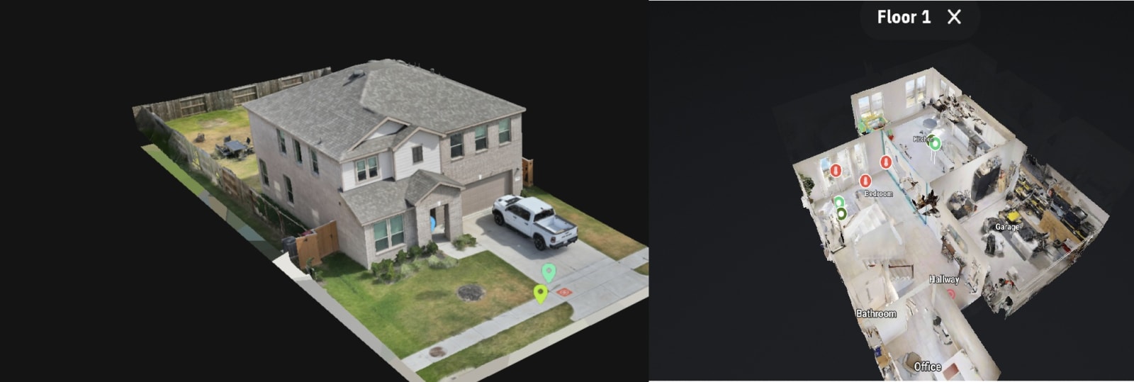
Matterport is one platform that can hold that walkthrough. On the IAQ and mold existing-conditions documentation demonstration, SterFlies used it for the interior record. The platform can present a navigable scan of the space that was walked. It is a method, not the service. Another ground-based system can be the right tool when the scope, the access, or the deliverable is different. The service is the documentation decision: what had to be preserved, and which capture could preserve it.
Room relationships and access are part of what the walkthrough keeps. Which rooms connect, where a sampling location sat relative to a return or a wall, and how a person moved from the entry to the area in question are visible in the path. They are context for a later professional. They are not, by themselves, a finding about air quality, moisture, or cause.
How the datasets complement each other

Used together, the exterior model and the interior walkthrough cover the gap between the lot and the room. The exterior record shows site relationships: envelope, roof, yard, and approach. The interior record shows the rooms those elevations belong to, the path through them, and the equipment and finishes a reviewer needs to see in place. Annotated imagery can mark a location in either record so a later reader can find it without guessing which photograph was which.
The IAQ demonstration project is the clearest SterFlies example. It paired a ground-based interior walkthrough with an exterior photogrammetric model of the same building, so room layout and envelope conditions could be reviewed together. Sampling labels in that model are fictional and were placed to show how locations can be marked. The project does not report moisture readings, exposure, or a cause. It shows the documentation structure: interior continuity plus exterior context.
Where the combination is used
Incident investigations often need both scales. The exterior capture can preserve the site arrangement, access, and visible damage on roofs or yards while those conditions still exist. The interior capture can preserve the rooms and equipment involved. How that exterior mapping fits an investigation is discussed in forensic mapping for incident investigations. The combined record supports later review. It does not determine how the incident happened.
IAQ and mold assessments are a direct case, because the question is often how an interior location relates to the envelope, the drainage, or an adjacent space. Construction-defect and property-loss reviews have the same structure. An interior symptom and an exterior condition need to be seen in relation, and the site may be repaired before the reviewer returns. Industrial facilities add equipment, aisles, and process areas that an overhead flight will never enter. Existing-conditions documentation before a renovation or a transaction is the same pairing without an incident: what the outside looked like, and how the inside was arranged, on a stated date.
In each of these, the deliverable follows the question. An exterior 3D model, an orthomosaic, a point cloud, an interior walkthrough, annotated imagery, and measurements on surfaces the capture can support are all possible. None of them is automatic. A project that only needs the exterior should not be sold an interior scan, and a project that turns on room relationships should not stop at the roof.
Limitations
The datasets may not share one coordinate framework. Aerial photogrammetry can be tied to surveyed control when the scope includes that work. An interior walkthrough is often a local model of the walked space. Placing both files in one viewer does not mean a distance from a room corner to a yard feature has been surveyed. If a shared frame is required, it has to be part of the scope, and the delivery has to say whether it was achieved.
Occlusion remains. The flight misses interiors and hidden exterior faces. The walkthrough misses spaces that were locked, unsafe, or outside the agreed path, and it misses the site beyond the doors. Transitions at thresholds, courtyards, and overhangs are where the two methods meet and where alignment is easiest to overstate. Measurements stay inside the limits of each method: visible surfaces, sufficient coverage, and any control that was actually used. Professional interpretation of cause, defect, contamination, or loss stays with the qualified reviewer. The capture preserves context for that review.
Conclusion
Exterior photogrammetry records the site and the envelope that an aircraft can see. Interior reality capture records the rooms, the path, and the equipment that it cannot. Together they close a documentation gap that either method leaves open. They remain two datasets, with two sets of limits, unless a project specifically ties them.
Matterport, or any other walkthrough platform, is the tool for the interior half when it fits the scope. It is not the service, and it is not a finding. If a site needs both the exterior and the interior preserved before conditions change, contact SterFlies with the question the record has to answer. The capture plan should follow that question, and the delivery should say what each method did and did not see.