
Introduction
A point cloud is one of the files people receive when a site has been mapped, and it is also one of the easiest to misread. It looks like a picture that can be rotated. It is not a picture. It is a set of estimated positions on surfaces the camera, or another sensor, was able to see.
Forensic consultants, construction teams, industrial hygienists, and facility reviewers encounter that file when they need geometry: how far a feature sat from another, what the visible surface of a pile or a roof looked like, or how an exterior related to the rest of a site. The file can support that review when the capture was planned for it. It does not arrive with a universal accuracy, a survey certification, or a conclusion about cause.
This article explains what a photogrammetric point cloud is, how it differs from a mesh and from an orthomosaic, what kinds of measurements it may support, and where the record stops. The practice that produces these files is described under mapping and photogrammetry. How a mesh is built from the same photographs is covered in exploring interactive 3D models.
What a point cloud is
A point cloud is a collection of points in three-dimensional space. Each point has a position. In a colorized cloud, many points also carry a color taken from the photographs used to reconstruct them. Together, the points sample the surfaces that were visible during capture: ground, a roof, a wall, a stockpile, equipment that did not move, or the face of an excavation.
The useful thing about the cloud is that those samples can be rotated, sectioned, and compared. A reviewer can look at the relationship between a pad and an access road, or between a building face and the yard in front of it, without being limited to the viewpoint of one photograph. The cloud is a spatial record of what was visible. Empty space between points is not a measured surface. Software may later connect the points into a mesh or a grid, and that connection is a further product, not a fact already stored in every gap.
How a photogrammetric point cloud is created
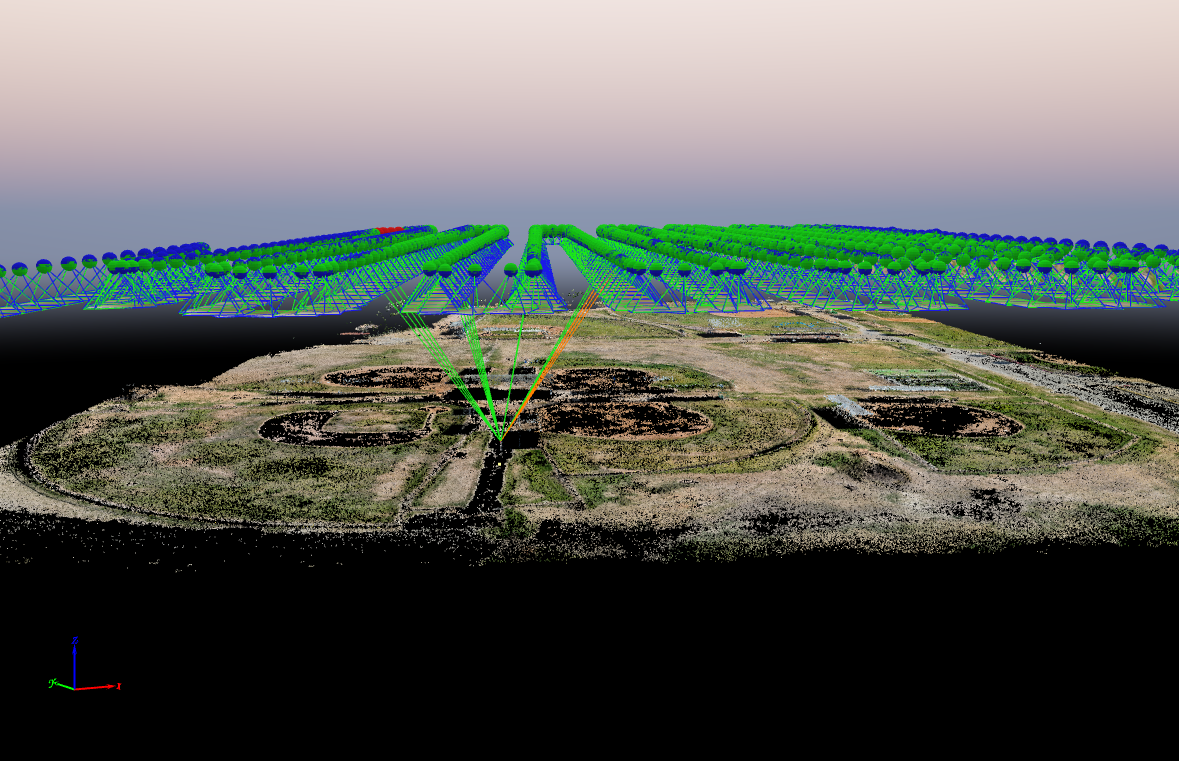
Photogrammetric clouds used in site documentation usually start as overlapping still photographs. Processing software finds features that appear in more than one frame, estimates where the cameras were, and then estimates where those features sit in space. A first, sparse set of tie points is enough to align the cameras. A denser cloud is then built by estimating many more positions across the surfaces the photographs actually show.
That sequence is the ordinary structure-from-motion path described in technical processing literature, including U.S. Geological Survey workflow documentation for overlapping aerial imagery. The details of the software settings change. The dependency does not. If two photographs do not share enough visible surface, there is nothing to match, and that part of the site does not become points. Pix4D’s own product description is consistent with this: a densified cloud is a reconstructed set of 3D points, computed from the earlier tie points, and color can be stored with position. That description defines the file. It is not a statement that every cloud supports the same measurement.
SterFlies produces this kind of cloud when the engagement asks for a spatial dataset, not as an automatic attachment to every flight. The capture plan—overlap, altitude, surface, and any control—is what makes the later file usable or not.
Density, color, and coordinates
Point density is how closely those samples are spaced. A denser cloud can describe a small edge or a narrow trench more clearly than a sparse one, provided the surface was visible and the photographs could support the extra points. Density is not accuracy. A cloud can be dense and still sit in the wrong place relative to a map grid, or dense on the near face of an object and empty on the far face.
A colorized, or RGB, cloud paints those points with color from the source photographs. Color helps a reviewer recognize a material, a marking, or a piece of equipment. It does not add a measurement. A gray cloud and a colorized cloud can describe the same geometry. Color is a viewing aid and, sometimes, a way to connect the geometry back to the photographs.
Coordinates are the other half of the file. Each point is stored in some coordinate reference system, or in a local frame that has not been tied to one. A projected grid, a horizontal datum, and a vertical datum are different choices. Mixing a cloud from one system with a drawing from another shifts the model even when both files look correct on their own. At the level that matters for review, the question is simple: what frame was this cloud placed in, and was that frame the one the rest of the project uses? The answer belongs in the delivery notes for that engagement. It is not implied by the file extension.
Point clouds, meshes, and orthomosaics
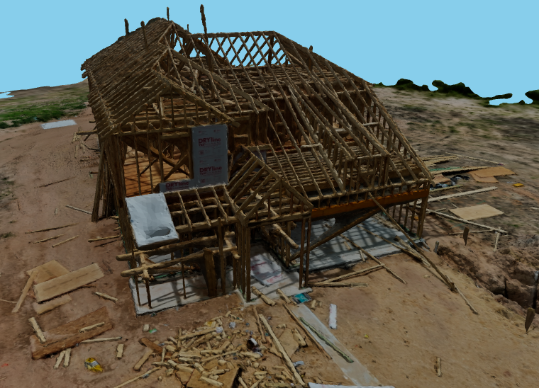
A mesh takes the cloud, or the same photographs, and builds a continuous surface of triangles. That surface is easier to walk through in a viewer, and it is what most people mean by a 3D model. The mesh can hide how sparse or noisy the underlying points were. Where the cloud had a hole, the mesh may still show a face, because the software interpolated one. For review of form and context, the mesh is often the right deliverable. For a question about what was actually sampled, the cloud is the more direct record.

An orthomosaic is a scaled, plan-view image. Relief displacement is reduced so the map can be read from above. Distances and areas on that map are two-dimensional questions. The cloud is the three-dimensional sample those map pixels were built from, or built alongside. A reviewer who needs layout across a site often starts with the orthomosaic, described in understanding orthomosaic mapping. A reviewer who needs height, a section, or the shape of a surface goes to the cloud or to a surface made from it. Neither product replaces the other, and neither is a photograph’s substitute for a licensed survey.
What measurements may be possible
When the capture was planned for measurement, a cloud can support distances, height differences, areas, and volumes on the surfaces it actually contains. A section through a stockpile, a clearance between two visible objects, or a comparison of two clouds from compatible visits are the ordinary uses. Volume work, in particular, depends on a defined base and on a surface that was visible. That limit is discussed in volumetric data from photogrammetric surfaces.
The measurement is only as good as the capture and the control behind it. Overlap, camera geometry, surface texture, and whether the cloud was tied to surveyed control or left in a relative frame all change the result. ASPRS positional-accuracy standards treat accuracy as a tested property of a geospatial product, not as a label that arrives with the sensor. SterFlies does not publish a universal accuracy for point clouds. A figure, if one is required, has to be defined for that project and checked by the method the project specified. How control and checkpoints fit that check is covered in RTK, ground control, and checkpoints.
Why surfaces go missing
The cloud contains surfaces the photographs could see from more than one position. Occlusion removes the rest. The underside of a slab, the ground beneath a vehicle, the back of a tank, and the interior of a building are absent unless something else captured them. A hole in the cloud is information. It means that surface was not sampled. Filling the hole for a prettier model does not create the missing observation.
Some surfaces are visible and still reconstruct poorly. Vegetation moves and hides the ground, so a cloud of a tree canopy is not a cloud of the grade beneath it. Reflective glass, water, and polished metal give the matcher false or shifting features. A homogeneous surface—fresh snow, a blank wall, still water, or a textureless paved area—may not offer enough detail for the software to decide where one point ends and the next begins. The practical result is noise, a gap, or a surface that looks complete and is not reliable for a close measurement. Those limits should be stated with the delivery, not discovered when someone tries to measure across them.
A point cloud is not a survey
A mapped point cloud can be useful and still not be a land survey. A survey, in the sense that determines boundaries, easements, or other legal location, is the work of a licensed surveyor under the rules of that jurisdiction. Photogrammetry can document visible surfaces and, when controlled and checked, support measurements the project defined. It does not stamp a boundary, certify an as-built, or establish a property corner because the file contains coordinates.
The same restraint applies to forensic and industrial use. The cloud can show where visible features sat relative to one another at the time of capture. It cannot determine how an incident occurred, whether a condition was defective, or who was responsible. Those questions stay with the qualified reviewer. The documentation role is described under forensic mapping and site documentation.
How the record is used
In ordinary site review, the cloud is a way to look at geometry after the site has changed or after the reviewer has left. Teams use it to see layout, to check a visible clearance, or to compare a later visit with an earlier one when both captures were planned to be compared. The 65-acre site mapping project is an example of repeat aerial mapping used as a shared spatial record of grading, utilities, pads, and access. The delivered map for that work was an orthomosaic and a web map. A cloud is the related spatial dataset when the scope asks for one, not a result that project claimed on its own.
On construction and industrial sites, the same file can hold the visible shape of earthwork, material piles, equipment surroundings, and large exterior surfaces while they still exist. It is a record of those surfaces. It is not a pay quantity, a safety determination, or an inventory system. In a forensic or existing-conditions context, the cloud preserves spatial relationships that scattered photographs lose: how an excavation sat in a yard, how a roof plane met a wall, or how access approached a work area. Interior rooms still need a ground-based method. An overhead cloud does not see them.
Exports and limitations
When the processing method and the engagement specify them, SterFlies can provide technical exports such as LAS for the cloud, GeoTIFF for raster map products, or OBJ for a mesh. The format does not improve the geometry. A LAS file of a poorly controlled cloud is still a poorly controlled cloud. A viewer or a web model may be the agreed way to look at the same data. The delivery should say which file is the cloud, which coordinate frame it uses, and what was not captured.
The standing limitations are the ones already described. The cloud samples visible surfaces only. Density is not accuracy. Color is not a measurement. Control, overlap, and surface conditions decide whether a distance is meaningful. Occlusion, vegetation, reflection, and textureless areas leave gaps or noise. The file is not a boundary survey, not a causation finding, and not evidence merely because it is three-dimensional.
Conclusion
A point cloud is a set of estimated positions on surfaces a capture could see. Photogrammetry builds it from overlapping photographs. A mesh makes those points easier to view. An orthomosaic makes the same site easier to read from above. Measurements are possible when the capture and the control were planned for them, and they remain measurements of that reconstruction, not a licensed survey.
Used with those limits stated, the cloud is a serious site record for construction, industrial, and forensic review. Used as if every point were a surveyed coordinate, it overstates what the method did. If a project needs a cloud, a mesh, or a map, discuss the documentation objective before the capture is planned. The file should follow from that objective.