65-Acre Neighborhood Development – Orthomosaic Monitoring
Executive Summary
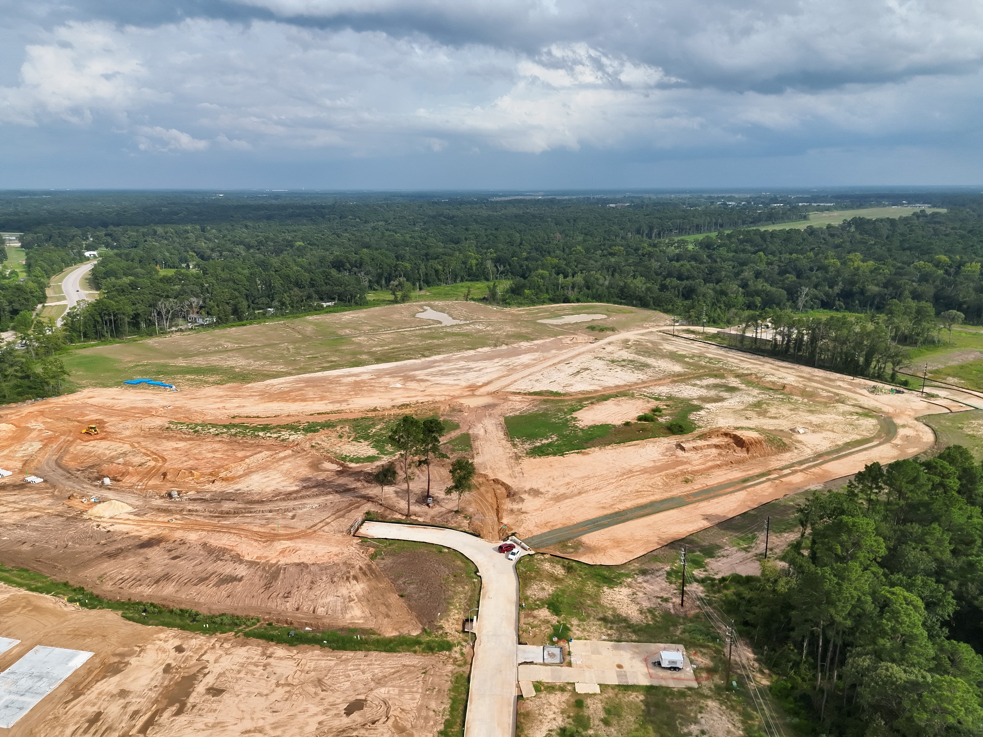
This 65-acre neighborhood development is a living jobsite: cut/fill, utilities, pads, roadway subgrade, and staging for vertical construction often move in parallel. The team needed a reliable way to see the whole site frequently without pausing work or waiting on a long survey cycle. We run a recurring drone capture that publishes a high-resolution, web-viewable orthomosaic. It’s the shared visual baseline: planners coordinate utilities and pads; supers drop pins for RFIs; subs check access and staging; owners and lenders get a clear, date-stamped snapshot of change.
This deliverable is a georeferenced, measurable surface—not just a pretty image. In the browser you can pan/zoom, measure lengths/areas, and compare phases over time. By syncing flights with active earthwork and utility pushes, decision-makers get the right view at the right moment.
Interactive Orthomosaic
Pan, zoom, and measure directly in the viewer. Open full screen for best clarity.
Notes: Web measurements are ideal for coordination; stamped records remain with survey.
Stakeholder Workflows
Developer / Ownership
Durable visual record for lenders and partners. Reduces unnecessary walkthroughs and clarifies sequence of work against the schedule of values. Bookmarks capture key milestones—subgrade, first lift, utilities tied-in—and support quick approvals.
General Contractor
Supers reference the map during morning huddles to orient new subs, set traffic flows, and mark restricted zones. PMs use in-browser measurements for quick quantity checks and to accelerate clarifications with the design team.
Civil / Survey
Not a substitute for stamped topo, but a fast sanity check: intent vs. reality, stockpile creep, slopes tracking plan. Provides context that helps direct where to spend field time between survey cycles.
Vendors / Subs
Quick link for access routes, staging, and deliveries. Reduces phone calls and prevents surprises when mobilizing to the site.
Quality Assurance
- Consistent altitude & camera geometry for repeatable pixel size.
- Morning flights to reduce heat shimmer and harsh shadows.
- Identical grid footprint with buffer—keeps seams stable across sessions.
- Aligned processing parameters for predictable blending behavior.
- Programmable flight paths to have consistent gps positioning.
Change Detection & Versioning
On a site this size, meaningful change happens fast—sometimes between Friday’s punch-list and Monday’s stand-up. Pads widen, trench lines jump lots, stockpiles migrate, and access routes pivot around weather or crew availability. A weekly or bi-weekly orthomosaic makes those shifts obvious at a glance, so coordination isn’t based on memory or texts from the field. Side-by-side views of prior captures answer, “What moved?” in seconds, letting PMs redirect trucks, resequence crews, and flag rework risks before they harden. Over time, the versioned mosaic library becomes a visual history of decisions: when the north spine tied in, where silt control crept, how staging evolved. It’s simple, fast change detection that keeps everyone building off the same picture of reality.
Risk & Safety Considerations
Launch/recovery away from haul roads, visual observers near heavy moves, and conservative wind/convective limits. Coordination with the superintendent on crane windows and temporary no-fly areas. Read-only share links as default; restricted shares for sensitive overlays.
Next Steps
- Save this week’s map as “Week of YYYY-MM-DD” so side-by-side comparisons are easy later.
- Optional monthly volumetrics with annotated pile IDs.
- Plan a quick oblique pass (low circle photos) once vertical work starts for clearer building context.