Introduction
Drone mapping is often sold with a single accuracy figure. The figure is usually a centimeter, sometimes attached to the words RTK or survey-grade. That sentence hides the thing a professional reader actually needs: which error is being discussed, what was used to place the model, and what was held back to test it.
Relative fit, absolute placement, ground control, checkpoints, flight geometry, and the surface itself are different parts of the same job. A project can be tight enough to compare two stockpiles and still not be tied to a published coordinate system. It can be tied to a coordinate system and still be wrong on a roof the photographs barely saw. RTK can improve the camera positions that go into the adjustment. It does not certify the map.
This article separates those terms for construction, stockpile, existing-conditions, and forensic work. It does not publish a SterFlies accuracy specification. The practice is mapping and photogrammetry. The map product those flights often become is described in understanding orthomosaic mapping.
Accuracy is not one number
A mapped product can be wrong in more than one way. It can be internally consistent and shifted on the ground. It can sit on the correct grid and still smear an edge that the photographs did not cover well. It can match the horizontal grid and miss the vertical datum the drawings use. Reporting one number, without saying which of those errors it describes, does not tell a reviewer whether the file will support the decision in front of them.
ASPRS positional-accuracy standards exist because of that problem. They treat accuracy as a tested property of a digital geospatial product, compared with independent checkpoints, and reported with a stated method. They do not treat “the drone was RTK” as a class. A delivery that needs an accuracy statement should say what was tested, in which directions, and against which points. A delivery that does not need that statement should not borrow one from a manufacturer brochure.
Relative accuracy and absolute accuracy

Relative accuracy is how well positions inside the model agree with one another. A distance measured between two visible features on the same reconstruction is a relative question. Absolute accuracy is how well those positions agree with an external frame: a published coordinate system, a surveyed control point, or a drawing the rest of the project already uses.
The distinction decides the workflow. Comparing the shape of a pile with a later visit, or measuring a clearance between two objects in one model, is often a relative problem, and it still depends on overlap and surface quality. Placing that pile on a site plan, or comparing it with a design surface, is an absolute problem. It needs a shared coordinate reference and a way to check that the model landed in it. Calling both results “the accuracy” is how a useful relative model gets treated as a surveyed coordinate file.
What RTK does
RTK, real-time kinematic positioning, corrects a GNSS receiver while it is moving. On a mapping aircraft, that receiver is estimating where the camera was when each photograph was taken. A base station, or a network correction service, sends the information that lets the rover reduce several ordinary GNSS error sources in real time. When the correction link holds, the camera positions that enter the photogrammetric adjustment are better than an uncorrected consumer fix.
Those camera positions help the software place the reconstruction. They are an input. They are not the map. Processing vendors describe RTK and related post-processed methods as a way to strengthen georeferencing, and some describe workflows in which ground targets can be reduced. That vendor language is about a processing option under favorable conditions. It is not a guarantee that a SterFlies map will meet a centimeter tolerance, and it is not a reason to skip a check the project actually requires.
What RTK does not guarantee
RTK does not repair a surface the camera never saw. It does not create texture on a blank wall, hold still a tree canopy, or see under a trailer. If the correction link drops, the positions for those photographs fall back toward a weaker fix, sometimes without the failure being obvious in a pretty orthomosaic. If the vertical datum of the correction does not match the vertical datum of the drawings, the model can be internally tight and still sit high or low relative to design.
RTK also does not replace an independent check. A reconstruction that used the corrected camera positions, and any control included in the adjustment, will tend to agree with the information it was given. Agreement with that information is not a test. A test uses positions the adjustment did not use. Centimeter-level results are reported for some RTK and ground-controlled workflows in vendor documentation and in research. Those results depend on the equipment, the correction source, the geometry of the flight, the processing, the site conditions, and the verification. They are not a universal SterFlies specification, and they are not implied by the presence of an RTK receiver on the aircraft.
Ground control points
A ground control point is a location on the site whose coordinates are known independently of the drone, and which can be identified in the photographs. In processing, those points are included in the adjustment so the reconstruction is pulled toward that external frame. They are how a project ties a model to surveyed positions when the engagement calls for that tie.
The points have to be visible, stable during the flight, and distributed across the area that matters, including elevation change when vertical placement matters. A cluster of targets in one corner does not control the far side of a site. Processing software will still produce a model. The far side will simply be less constrained than the corner that held the targets. How many points a job needs is a project decision. Vendor guides often suggest a range for general mapping. That suggestion is not a SterFlies rule, and it is not a substitute for the accuracy the drawings or the reviewer actually require.
Checkpoints are not control
A checkpoint is also a known position that can be seen in the photographs. The difference is how it is used. Control goes into the adjustment and helps place the model. A checkpoint is there to test the result. PIX4Dmatic’s tie-point documentation says checkpoints assess absolute accuracy and are not used to georeference the project. PIX4Dmapper treats them as a quality check and recommends measuring extra targets so some can be held back for that purpose. The mapper documentation also notes that marking a checkpoint can affect the local relative fit, so a reported error has to be read against how that software actually used the point. ASPRS accuracy testing rests on the stricter form of the same idea. A point that helped place the product is not an independent test of it.
Using every surveyed target as control produces a fit to those targets and no independent number at all. Holding a subset out of the georeferencing adjustment gives the delivery a comparison the adjustment did not build. That comparison is still only a statement about those locations, under that capture. It does not describe a roof, a vegetated edge, or a shadowed face that was never tested.
Geometry, altitude, and the camera

Image geometry is the pattern of photographs: how much they overlap, from how many directions a surface was seen, and whether the flight actually covered the area later questions will be asked about. USGS processing notes on structure-from-motion work record the practical failure mode. Where overlap is not sufficient, the reconstruction has gaps. Extra control does not invent the missing photographs.
Flight altitude and the camera together set the ground sample distance, the size of the ground represented by one pixel. A lower flight or a longer focal length can show smaller features. That is resolution. Resolution is not the same as positional accuracy. A fine pixel can still be in the wrong place. A coarser pixel can still be well placed for a question that does not need the finer detail. Lens, shutter, and the way the camera is mounted also affect whether features match cleanly from frame to frame. Those are planning choices for the engagement. They are not a standing accuracy claim.
Surface, processing, and the coordinate frame
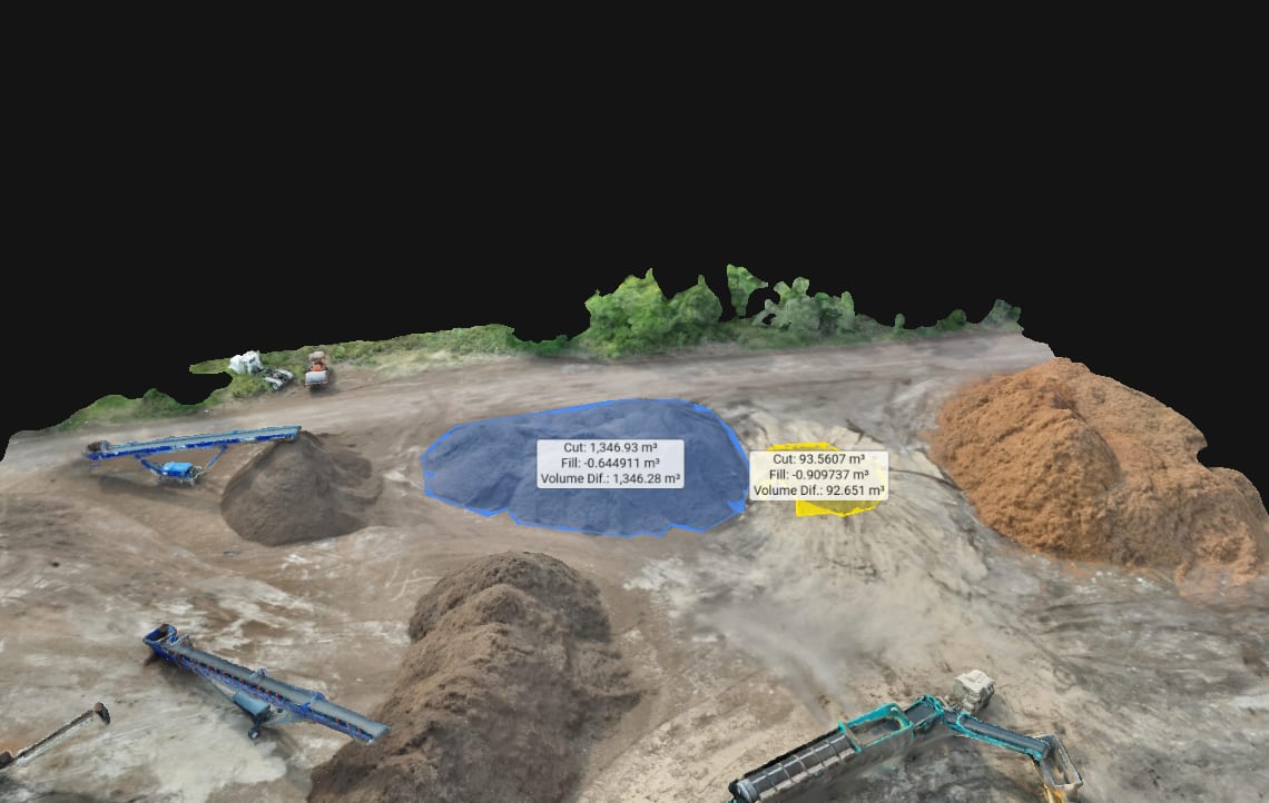
Surface conditions limit every method above. Vegetation hides grade. Water, glass, and polished metal confuse the matcher. A fresh, textureless pad may not offer features to tie. Moving equipment between frames becomes noise or a false surface. Those limits are discussed with the point cloud itself in point clouds for site documentation.
Processing quality is the set of choices made after the flight: which photographs are kept, how control is marked, whether checkpoints stay out of the adjustment, and how the dense surface is filtered. Aggressive smoothing can make a pile look clean and change its volume. Leaving noise in can make a flat pad look rough. The processing should match the question. Volume work has its own limits, covered in volumetric data, and topographic presentation has its own, covered in topographic maps.
The coordinate reference system is the frame those choices land in. Horizontal and vertical datums are not interchangeable. A model in one projected system will not sit on a drawing in another until someone transforms it, and a casual export does not perform that transformation correctly just because both files open in the same software. The delivery should name the frame. If the project does not need an external frame, the delivery should say the model is relative.
When a licensed surveyor is required
A licensed surveyor is required when the product is a land survey: boundaries, property corners, easements, and other determinations the jurisdiction reserves to that license. A surveyor is also the right source for control coordinates when the project needs the map tied to a legal or design framework the surveyor is responsible for. SterFlies can plan a flight around control a surveyor provides, and can document visible surfaces. SterFlies does not practice land surveying and does not certify a map as one.
Many documentation jobs never need that certification. A progress record, a relative comparison, or a visual spatial file for a reviewer can be the correct scope. The mistake is using those files later as if the certification had been part of the work. The scope should say which of those products is being ordered.
The requirement decides the workflow
Construction documentation often needs a shared picture of grading, pads, utilities, and access as work moves. The 65-acre site mapping project was that kind of record: repeat aerial mapping delivered as an orthomosaic and a web map so the team could see conditions as the site changed. That scope did not claim a boundary survey. A later job that must match design coordinates would add the control and the checks that scope actually omitted, because the requirement would be different.
Stockpile mapping is a volume and surface problem. The base, the visible material, and a consistent method between visits matter more than a slogan about sensor accuracy. Existing conditions work may need absolute placement when the model will be compared with drawings, and may only need a careful relative model when the question is what the site looked like. Forensic site mapping needs the same honesty about frame and gaps, because a later reader may treat the file as more certain than the capture was. In each case the workflow—RTK or not, how much control, how many checkpoints, what gets exported—follows the decision the file has to support. It does not follow a default centimeter.
Conclusion
RTK improves camera positions when the correction is valid. Ground control pulls a reconstruction toward known positions. Checkpoints test the result because they were not allowed to help build it. Overlap, altitude, the camera, the surface, the processing, and the coordinate frame decide whether any of that work produces a measurement the project can use. None of it, by itself, produces a legal land survey or a standing accuracy for every SterFlies map.
If a project needs a stated accuracy, the scope should name the frame, the control, the checks, and the decision the map has to support. Contact SterFlies with that requirement before the flight is planned. The method should be chosen for the question, and the delivery should say what was and was not tested.