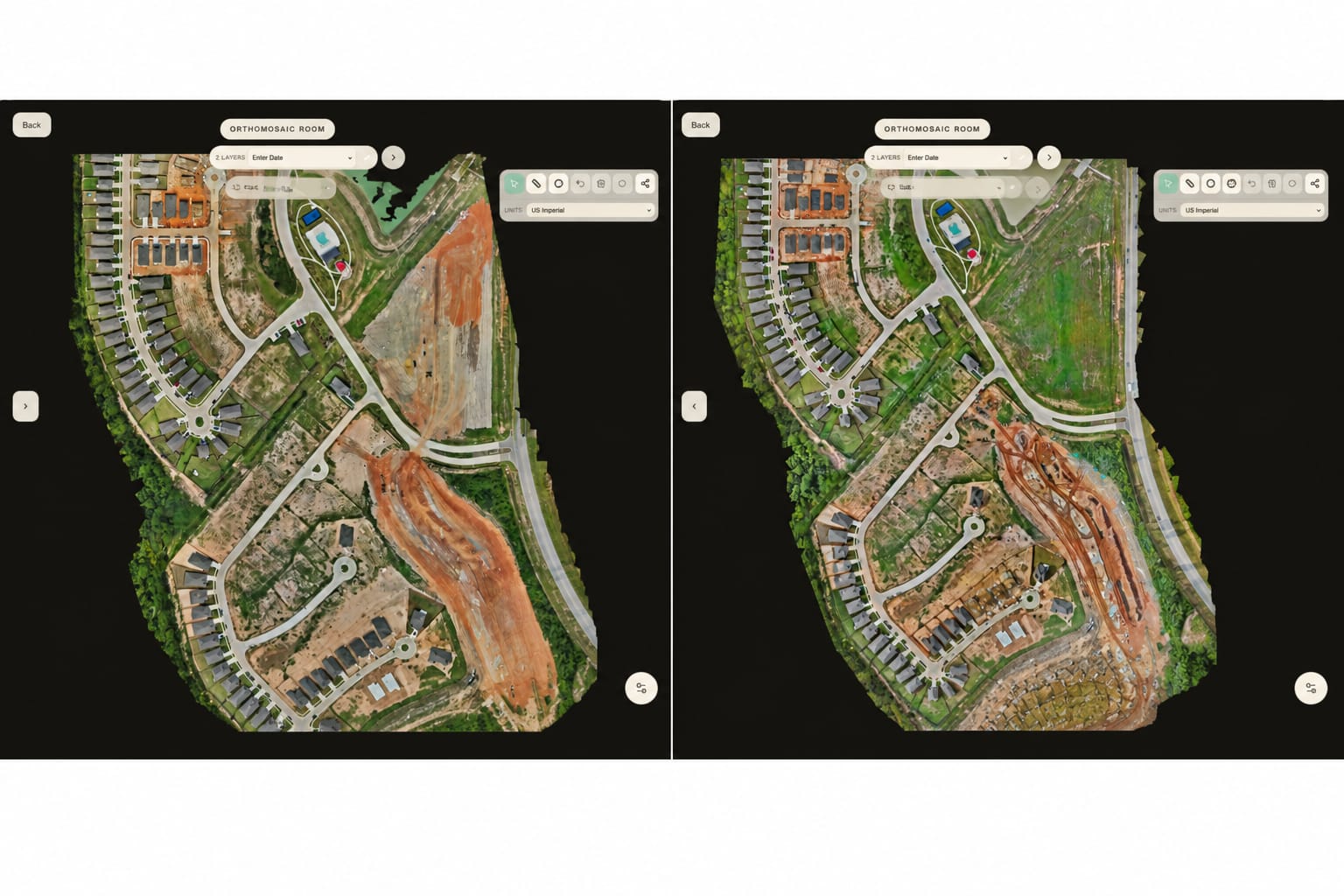
Construction sites rarely look the same from week to week. An area that was recently cleared may already have utilities installed. Excavations are backfilled, access roads shift, foundations take shape, and equipment moves between work zones. On larger projects, tracking those changes becomes a job of its own.
Project managers typically rely on daily reports, schedules, photographs, inspections, and conversations with personnel in the field. These methods remain necessary, but they have practical limits. A photograph of a completed foundation tells you something about the work. It may not explain how that foundation relates to the rest of the site or what conditions existed in the surrounding area before construction began.
Drone mapping offers another way to maintain that record. By collecting overlapping aerial photographs and processing them into orthomosaic maps, construction teams can document site conditions at various stages of a project. When mapping is repeated consistently, those records serve as a useful reference for tracking progress, coordinating work, and reviewing changes over time.
The Federal Highway Administration identifies construction progress tracking, quality control, quantity estimation, and safety inspections as among the applications of small, unmanned aircraft systems in construction (Federal Highway Administration).
The important part is knowing what information needs to be collected and how the project team plans to use it.
Establishing a Record Before Construction Changes the Site
The first useful mapping flight often occurs before significant construction begins.
At that stage, the site may contain existing roads, vegetation, drainage features, buildings, utilities, and neighboring properties that become harder to distinguish once work gets underway.
An initial orthomosaic provides a visual reference for those conditions.
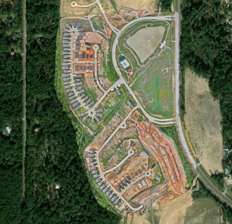
For example, consider a commercial development in which contractors will clear vegetation, establish access roads, grade, and begin utility installation.
A map captured before those activities can document the arrangement of visible site features. Later imagery can be compared with that initial record to examine how the property has changed.
This becomes especially useful when several contractors are working on the same project.
A superintendent might recall when an access road was relocated, but another project participant may have joined after the work was completed. Having dated maps allows both individuals to review the site's earlier arrangement without relying solely on memory or written descriptions.
The initial flight should also establish the mapping area and documentation objectives for future visits. If important parts of the property are outside the original capture, later comparisons may be less useful.
For recurring projects, it is worth documenting the flight boundaries, camera settings, intended deliverables, and the positional reference method from the start.
Why Consistency Matters Between Mapping Visits
A construction mapping program becomes more valuable when each visit yields information that can be compared with earlier records.
That requires more than flying over the property whenever convenient.
Flight altitude, image overlap, camera orientation, capture coverage, and positioning methods can influence the resulting orthomosaic. Significant changes between visits can make comparisons more difficult, particularly when measurements are involved.
In a study published in Sensors, Jacob-Loyola and colleagues developed a methodology for monitoring construction progress through repeated UAV inspections and photogrammetric models. Their work emphasizes planned capture trajectories, consistent observations, and the integration of collected data into project review workflows (Jacob-Loyola et al.).
For a typical construction mapping assignment, the operator should establish a repeatable flight plan tailored to the property.
The entire project does not necessarily need to be mapped at the same interval. A large development may benefit from periodic coverage of the entire property, while a specific work area may require more frequent documentation during an important construction phase.
The objective is consistency where it counts.
A map captured during initial grading should be useful when compared with another map collected after grading progresses. Maintaining a comparable capture area and positional reference helps make such comparisons possible.
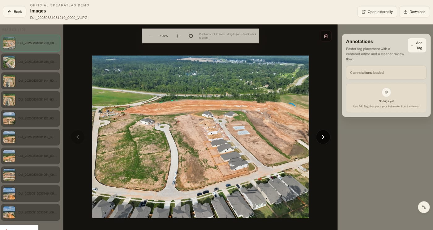
Lighting, shadows, weather, and temporary equipment placement can also affect how the site looks. These factors should be considered when reviewing imagery from different dates.
Most importantly, a visual comparison should not be mistaken for a verified measurement merely because the two maps appear to align.
Reading Construction Progress Through Orthomosaic Maps
An orthomosaic combines overlapping photographs into a corrected aerial image of the site.
Unlike a single aerial photograph, which contains perspective distortion, an orthomosaic is processed to provide a more consistent spatial representation of visible ground features.
For construction teams, its usefulness comes from the ability to examine the overall property while retaining enough detail to identify individual work areas.
Consider a project in the early stages of site development.
An orthomosaic may show completed clearing, graded surfaces, temporary access roads, stockpiles, equipment staging areas, and visible utility work locations.
Several weeks later, a second map may show completed building pads, changes to drainage features, new excavations, or relocated materials.
When the maps are displayed side by side, the progression is easier to follow.
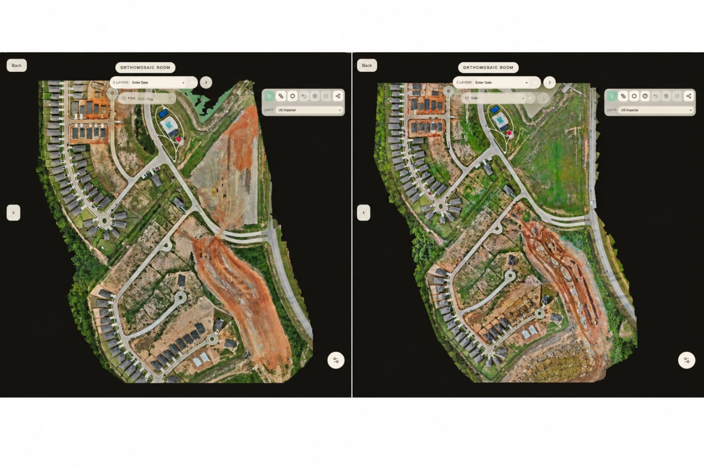
This approach is already used in construction management workflows. Pix4D has documented projects in which contractors regularly collected orthomosaics to review site quantities, coordinate work, and compare conditions across dates (Pix4D, "How PIX4Dcloud Advanced Boosts Construction Site Management").
The distinction between observing progress and verifying completed work remains significant.
An aerial map may show that a foundation has been poured. It cannot independently establish whether the concrete meets specifications, whether embedded components were installed correctly, or whether the work has passed inspection.
Those determinations require the appropriate project records, testing, inspections, and professional review.
Drone mapping provides visual context for that process.
Tracking Earthwork, Grading, and Material Movement
Earthwork is one of the more practical applications of construction drone mapping.
During site development, contractors may move substantial quantities of soil and aggregate to establish elevations, prepare building pads, excavate for utilities, and construct access roads.
Aerial photographs can document the visible extent of those activities. When the project is captured and processed using appropriate methods, photogrammetric surface models can also support area and volume calculations.
The Federal Highway Administration's technical brief Use of Small UAS for Construction Quantity Estimation examines applications for earthwork, stockpiles, and construction quantity verification.
The report explains that drone-derived data can support quantity estimation and emphasizes the importance of planning, positional accuracy, data processing, and quality control (Federal Highway Administration).
A practical example is a contractor managing multiple stockpiles across a development.
An aerial map can show where the stockpiles are located and how the storage areas are laid out.
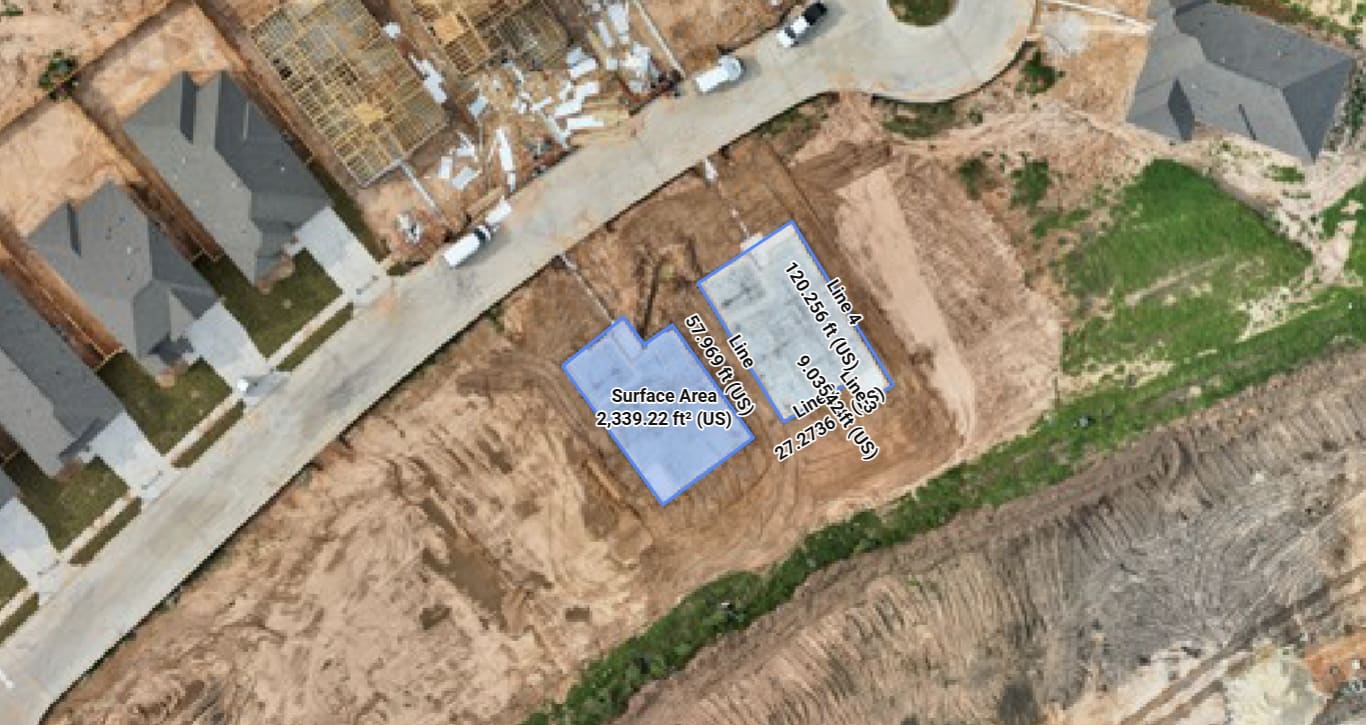
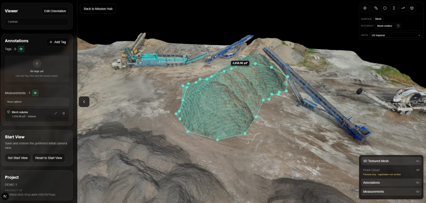
If volume measurements are required, the mapping assignment must be planned to generate suitable three-dimensional data. The accuracy requirements, stockpile boundaries, reference surfaces, and processing methods all affect the resulting volume.
Photogrammetric estimates should not be automatically treated as certified survey quantities.
For projects involving payment applications, engineering calculations, or contractual verification, measurements may require confirmation by a qualified professional.
Even when volume calculations are not part of the deliverable, the dated imagery provides a useful record of where material was stored and how those areas changed throughout construction.
Recording Work That Will Eventually Be Covered
Some of the most useful construction photographs are taken before the work is gone.
Underground utilities serve as a good example.
Once the trenches are backfilled and the surrounding area is graded, the visible arrangement of pipes, conduits, and excavations is no longer suitable for ordinary photography.
Aerial documentation collected while the work is exposed can preserve the visible layout of the installation.
The same principle applies to foundations, drainage features, and other construction elements that become partially concealed as construction progresses.
However, timing is critical.
A monthly mapping schedule may be sufficient for reviewing general site development but may completely miss a utility installation that is excavated, completed, inspected, and backfilled within several days.
For this reason, recurring mapping should be supplemented with milestone documentation as needed.
A contractor might request additional imagery before backfilling, before a concrete placement, or immediately after completing a phase.
Ground photographs remain especially important for documenting connections, installation details, identification markings, and features that are not clearly visible from above.
For certain projects, combining aerial mapping with detailed ground photography or interior reality capture can yield a more complete record.
The purpose is not to photograph everything indiscriminately. It is to identify which conditions will be difficult to document later and to capture them while they remain accessible.
Using Aerial Records During Construction Coordination
A construction project can involve owners, general contractors, subcontractors, architects, engineers, inspectors, and other consultants. Each group may need different information about the same site.
An orthomosaic provides a shared visual reference for discussion during coordination meetings. Instead of relying solely on descriptions such as "the excavation behind the south building," a reviewer can identify the relevant area directly on the map.

Annotations can mark locations requiring attention, identify work zones, or link a particular area to supporting photographs and documents.
For example, a project manager reviewing a development may want to identify the following:
- Areas where grading remains incomplete.
- Access routes affected by ongoing construction.
- Locations where materials or equipment occupy planned work areas.
- Visible changes to temporary staging or storage locations.
- Work zones requiring closer ground-level review.
These observations can help project personnel determine where to focus their attention during the next site visit.
An annotated aerial image is especially useful when the person reviewing the project is not on-site.
However, a map should not replace communication with the personnel responsible for the work. An image collected several days earlier may no longer reflect current conditions.
The capture date should always be clearly stated.
Reviewing Site Conditions With Safety in Mind
Construction progress and site safety are closely connected, but they entail different responsibilities.
As work progresses, the arrangement of equipment, excavations, temporary access routes, and material storage can change.
Recurring aerial documentation may help safety professionals review specific visible conditions across a project.
For instance, a map may show that equipment staging has expanded into an area previously used for site access. An overhead photograph may also help identify the location of an excavation relative to nearby structures or active work zones.

These observations can inform questions during a subsequent safety inspection.
By themselves, they do not establish that a site is safe or that a contractor has complied with applicable regulations.
Spear & Lancaster emphasize the importance of monitoring contractor safety performance during active projects. Their publication Improving Contractor Safety Performance identifies work-in-progress assessments, inspections, and safety reporting as components of an effective monitoring program (Spear and Lancaster).
Aerial documentation can supplement those activities by providing additional views of the visible site conditions.
Without further evaluation, it cannot determine whether an excavation has adequate protective systems, whether workers are following required procedures, or whether a particular operation meets OSHA requirements.
Some conditions may not even be visible from the air.
Work beneath structures, internal building activities, equipment operation, and temporary conditions may require direct observation by qualified personnel.
The aircraft also poses operational hazards. Drone flights must be coordinated around workers, cranes, power lines, equipment, airspace restrictions, and other site activities.
The appropriate approach is to use the aerial record as supporting information while leaving safety assessments to the professionals responsible for conducting them.
Comparing Construction Plans With Existing Site Conditions
Another application involves using mapped imagery alongside drawings or digital design data.
Construction drawings show what is intended to be built. An orthomosaic records the visible site conditions at a particular time.
Displaying the two together can help project personnel identify locations that warrant closer examination.
For example, a mapped construction site may be compared with a proposed building footprint, an access road alignment, or a utility layout.
If a visible feature appears to be in a different location than intended, that discrepancy can be flagged for review.
Pix4D has published construction case studies comparing drone imagery with design information. In one example involving W.E. O'Neil Construction, regularly collected aerial data helped project personnel review planned concrete deck penetrations before concrete placement (Pix4D, "$100,000 Saved").
That example illustrates the value of identifying questions while the work is still accessible.
There are limitations.
A visual overlay is only as useful as the positional accuracy and alignment of the underlying data.
Drawings and maps must use compatible reference systems, and relevant tolerances must be considered.
When the question involves design compliance, property boundaries, elevations, or other precise measurements, qualified surveyors or engineers may need to verify the information.
Drone mapping can help identify where a question arises. It should not be presented as the final authority on whether the constructed work conforms to design requirements.
Matching the Mapping Schedule to Construction Activities
One of the first decisions in a recurring mapping project is how often the site should be documented.
No single schedule fits every construction project.
Weekly mapping may be useful during active grading or rapid site development. Other projects may benefit from documentation every two weeks, monthly visits, or milestone-based captures.
The appropriate interval depends on the construction pace and the information the project team needs.
A practical schedule might look like this:
| Construction phase | Suggested documentation focus |
|---|---|
| Before construction | Existing conditions, property access, vegetation, drainage, and surrounding structures |
| Clearing and grading | Earthwork progression, equipment access, stockpiles, and developing building pads |
| Underground utilities | Exposed installations, excavation locations, and conditions before backfilling |
| Foundations | Foundation locations, surrounding work areas, and visible construction milestones |
| Vertical construction | Building progress, material staging, access routes, and exterior work |
| Site improvements | Paving, drainage features, landscaping, and remaining exterior construction |
| Project completion | Final visible exterior conditions and the completed site arrangement |
This is a suggested documentation framework, not a required inspection schedule.
The capture plan should reflect the project scope, access restrictions, and agreed-upon deliverables.
A project involving extensive underground work may need additional ground photographs or specialized documentation between aerial visits.
A smaller building project might benefit more from periodic 3D models that document changes to the exterior structure.
The best schedule collects information when conditions are most relevant.
What a Construction Mapping Package Should Include
A useful mapping deliverable should be understandable to someone who was not present for the flight.
The exact contents depend on the assignment, but construction documentation packages commonly include an orthomosaic, supporting aerial photographs, and information identifying the capture date.
Additional deliverables may include:
- A dated map showing the full project area.
- Oblique aerial photographs of buildings and active work zones.
- A 3D model or point cloud where geometry is needed.
- Annotations identifying locations or conditions of interest.
- Surface or volume measurements when properly scoped and verified.
- A comparison with imagery collected during earlier visits.
- Supporting files and measurement limitations relevant to technical review.
The format should align with the intended audience.
A superintendent may need a straightforward map that can be opened during a meeting.
An engineer may need access to spatial data, coordinate information, or measurements.
An owner may prefer a chronological collection of visual progress records.
Keeping the original captures and processed deliverables organized is important, especially when the records may later be used to resolve questions about project history.
Documentation should also distinguish between observations and conclusions.
A photograph of an incomplete work area records visible conditions. Whether the work was behind schedule requires comparison with the applicable project schedule and other information.
Likewise, a measured surface difference may require additional verification before it can support a contractual or engineering decision.
Making Construction Records Useful After the Project
Construction photographs are often reviewed most frequently during a project's active phase.
Their usefulness does not necessarily end once construction is complete.
Dated aerial records may later help project teams locate earlier work areas, review the sequence of visible site changes, and understand how access and surrounding conditions evolved over time.
They can also provide background information when questions arise during renovations, maintenance, property improvements, or during later technical investigations.
The value depends heavily on how the records were collected and organized.
Unidentified drone photographs are difficult to use several years later. A chronological set of maps with consistent coverage and clear supporting information offers a much better reference.
That is why mapping should be planned as part of the project's documentation process rather than treated as an occasional photography task.
SterFlies provides aerial mapping, photogrammetry, and related technical documentation for construction and industrial projects. These services can produce orthomosaics, site imagery, and three-dimensional records tailored to the needs of a particular assignment.
Construction managers, engineers, safety professionals, and other qualified project personnel remain responsible for interpreting those records within their disciplines.
Drone mapping is most useful when it answers practical questions: What did this area look like at the time, what has visibly changed, and what information should the project team examine next?
A consistent mapping program gives project teams a way to revisit those questions throughout construction, with a dated visual record to support their review.
Works Cited
Federal Highway Administration. Use of Small UAS for Construction Quantity Estimation. FHWA-HIF-23-058, U.S. Department of Transportation, Sept. 2023. https://www.fhwa.dot.gov/uas/resources/hif23058.pdf.
Jacob-Loyola, Nicolás, et al. "Unmanned Aerial Vehicles (UAVs) for Physical Progress Monitoring of Construction." Sensors, vol. 21, no. 12, 2021, article 4227. https://doi.org/10.3390/s21124227.
Pix4D. "How PIX4Dcloud Advanced Boosts Construction Site Management." Pix4D, 23 Mar. 2022. https://www.pix4d.com/blog/drone-construction-site-management.
Pix4D. "$100,000 Saved: Using PIX4Dcloud Advanced in Construction." Pix4D, 13 Apr. 2022. https://www.pix4d.com/blog/as-built-data-placing-concrete-with-drones.
Pix4D. "What Is the Relative and Absolute Accuracy of Drone Mapping?" PIX4D Documentation. https://support.pix4d.com/hc/en-us/articles/202558889.
Spear and Lancaster. "Improving Contractor Safety Performance." Spear and Lancaster. https://jespear.com/improving-contractor-performance/.