
Why fragments are not enough
Traditional documentation workflows usually focus on isolated details. A crack is photographed. A stain is captured. A roof seam is documented. A wall cavity is imaged. These records can be sharp and technically competent, but they rarely preserve the structure of the environment. Without spatial continuity, it becomes difficult to answer the questions that matter in high-stakes decisions.
Where exactly was this captured within the structure. What is adjacent to it. What sits above or below it. How far is it from a suspected source. How does it relate to drainage, slope, penetrations, access routes, or mechanical systems. When evidence exists only as fragments, interpretation becomes unavoidable, and interpretation is where defensibility weakens.
A defensible record is not just “more documentation.” It is a single source of spatial truth. It is a capture that allows any qualified reviewer to orient themselves, validate location and relationships, and revisit the environment without relying on the person who was there to narrate what matters. That is the difference between persuasive evidence and verifiable evidence.
SterFlies approaches preservation differently. The objective is not simply to record visible issues. The objective is to reconstruct the environment so spatial relationships, context, and measurable geometry remain available even after the site changes.
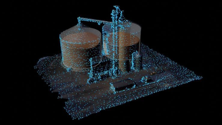
Exterior reconstruction preserves context at scale
Large properties present a documentation challenge that ground level capture alone cannot solve. Industrial facilities, commercial campuses, multi-building developments, solar sites, and large residential projects all require an approach that preserves site wide context. Exterior factors frequently explain interior conditions. Roof geometry, drainage patterns, parapet transitions, penetrations, grading, and proximity to retention zones can all influence moisture migration and failure pathways.
SterFlies uses aerial capture and 3D reconstruction to preserve entire properties as continuous spatial datasets. This does not exist to create attractive visuals. It exists to preserve orientation, scale, and relationships between features so future reviewers can evaluate conditions within the full context of the property rather than through disconnected images.
This matters because defensibility improves when selective framing is reduced. When the exterior environment is preserved as a cohesive reconstruction, stakeholders can independently evaluate how site wide conditions relate to localized issues, and the record becomes harder to challenge.
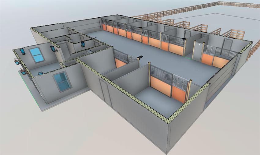
Interior LiDAR scanning creates navigable digital twins
Interior environments are especially vulnerable to documentation gaps. Rooms connect in sequence, hallways branch, mechanical runs intersect above ceilings, and subtle elevation changes can matter when analyzing pathways, access, and adjacency. Without structured capture, orientation is easily lost.
SterFlies recreates interior spaces using LiDAR based scanning that produces navigable digital environments. Instead of relying on photo folders and written descriptions, a stakeholder can move through the space virtually, maintain orientation, verify room-to-room relationships, and understand how conditions relate to the broader layout.
The value here is not convenience. The value is structural integrity of the record. Attorneys, consultants, engineers, adjusters, and decision makers can independently explore the same preserved environment. That reduces miscommunication, minimizes interpretation drift, and decreases the need for repeat site visits that may not even be possible later.
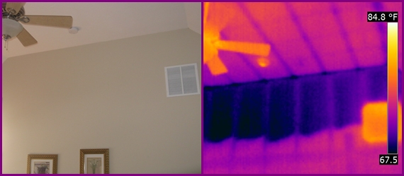
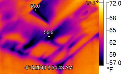
Thermal integration adds an investigative layer, not a standalone claim
Not all conditions are visible. Moisture migration, insulation deficiencies, heat loss, and electrical anomalies often require infrared imaging to detect patterns. At the same time, thermal imagery can be misunderstood when captured without context. A temperature differential alone is not an answer. It is a signal that must be anchored to location, geometry, and surrounding conditions.
SterFlies integrates thermal capture into the broader reconstruction so thermal observations remain tied to place. When anomalies are associated with a preserved environment, they become easier to discuss, validate, and revisit. Thermal does not replace other investigative methods. It strengthens the record by adding another dimension that can be reviewed within the same spatial truth as the rest of the site.
In disputes involving moisture intrusion, envelope failure, roofing conditions, or insulation performance, a layered record reduces speculative interpretation. It creates a clearer basis for professional review and defensible decision making.
Remote accessibility and long-term preservation
Digital reconstruction changes how teams collaborate. Once a site is recreated, it can be accessed from anywhere. An attorney can review conditions without coordinating access. An expert can evaluate relationships without scheduling a second visit. A team can review the same environment together without debating orientation or reconstructing details from memory.
Time is just as important as accessibility. Physical sites evolve. Digital reconstructions remain stable. When conditions are captured at a point in time and preserved as a navigable environment, stakeholders retain access to that moment even after cleanup, remediation, repairs, or renovations occur.
Defensibility comes from structure
Defensibility is not achieved through technology alone. It is achieved through continuity, measurable preservation, and a record that can stand on its own. A defensible record maintains spatial relationships across the property. It reduces selective capture by preserving broader context. It supports independent review by third parties. It preserves conditions as they existed at a defined moment in time.
SterFlies builds site environments with those principles in mind. By combining large scale exterior reconstruction, interior LiDAR scanning, and thermal integration, the output becomes more than documentation. It becomes a preserved environment that remains measurable and navigable even when the physical site has changed.
Closing perspective
Every site changes. What is not inevitable is losing the ability to reference how it existed when it mattered. SterFlies recreates sites as defensible digital environments that can be navigated, measured, and reviewed from anywhere. When time passes and conditions evolve, the record remains stable. In high stakes situations, structure is credibility. Preserved reality is leverage.
Need to preserve a site as evidence before conditions change
SterFlies recreates sites using drones, LiDAR scanning, and thermal imaging to produce navigable, measurable digital environments that support clearer review, stronger defensibility, and faster decisions.